The Environmental Excellence Awards (EEAs) recognize outstanding transportation projects, processes, and organizations that incorporate environmental stewardship into the planning and project development processes using Federal Highway Administration (FHWA) funding sources.
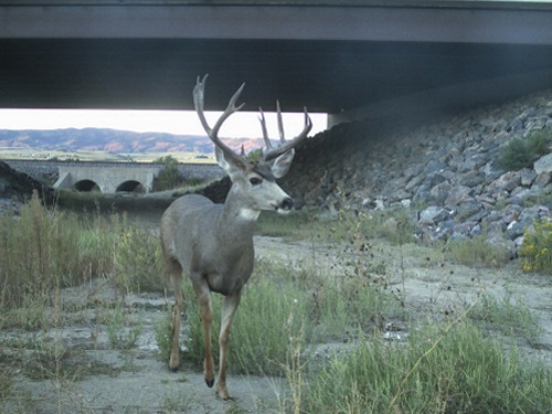
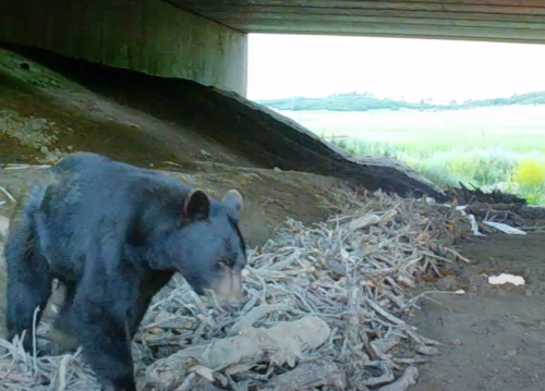
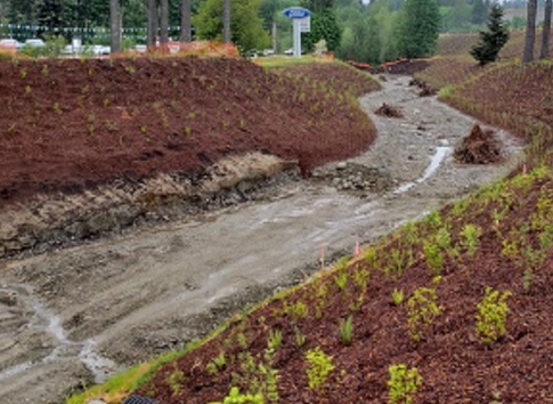
The Colorado Department of Transportation and the Colorado Parks and Wildlife (CPW) agencies recently completed wildlife underpasses along a rural stretch of Interstate 25 between Colorado’s two largest cities, Denver and Colorado Springs.
[Above photo by the Colorado DOT]
This wildlife mitigation system is part of a $419 million transportation improvement project – known as the I-25 South Gap project – that aims to improve safety and travel on 18 miles of I-25 south of the Denver metropolitan region; a route that more than 87,000 motorists use on a daily basis.
The I-25 South Gap project’s wildlife mitigation system includes four new and one refurbished wildlife underpasses, 28 miles of deer fencing, and deer guards and jump-outs, Colorado DOT said.
Work on the underpasses is substantially complete with 8 percent of deer fencing installed – just in time to shepherd migrating wildlife safely under the interstate this fall. The I-25 South Gap project as a whole, however, should be finished by 2022, the agency noted.
The Colorado DOT and CPW are also now in the process of installing 59 cameras throughout the project’s wildlife mitigation system to help measure success.
Shoshana Lew, executive director of the Colorado DOT, said that these wildlife underpasses – used by bears, elk, and small game animals – are also some of the largest in North America.
“One of [our] core values is safety, and we are thrilled to deliver on this value to all who use I-25 in the area,” she explained in a statement.
“In Colorado, nearly 4,000 animal-vehicle crashes are reported annually, resulting in injuries and fatalities to people and costing an estimated $80 million,” Lew added. “In the I-25 South Gap, it is estimated that one animal-vehicle crash occurs per day. Our wildlife mitigation system aims to reduce these crashes by 90 percent.”
Photo by Colorado DOT
“Colorado DOT met with various agencies, including CPW, early in the planning process to come up with a collaborative solution,” noted Brandon Marette, land use coordinator for CPW’s Northeast Region. “Fast forward from our first collaboration meeting nearly five years ago to today, where wildlife is now using the underpasses that we planned together. There is more collaboration to come between our agencies as we continue to plan and implement strategies to keep both people and wildlife species safe, thus protecting what is unique to Colorado.”
State departments of transportation in various parts of the country have been working on ways to improve wildlife mitigation tactics over the past several years.
In 2019, the Pew Trusts issued a report that highlighted the work states are doing to boost safe passage for wildlife around roadways, while at the same time improving motorist safety.
“Big-game animals in the American West today are increasingly squeezed by growing suburban areas, energy development, climate change, and an expanding road network,” noted Matt Skroch, a manager with the Pew Charitable Trusts’ U.S. public lands and rivers conservation team and author of the report, at the time.
“[Those] factors are threatening the landscape connections that wildlife needs to move to and from their seasonal feeding and breeding grounds,” he added. “To conserve wildlife corridors while reducing wildlife-vehicle collisions in the West, state and local governments need to take the lead on these issues and guide their agencies to effectively link science with policy. Fortunately, this is beginning to happen. From Montana to New Mexico, states are identifying hot spots where collisions occur and linking those areas with the larger habitat conservation needs on either side of the road.”
For example, in April, the construction of the new Rock Creek Bridge to replace a culvert on US-20 recently won an engineering excellence award from the American Civil Engineers Council of Idaho – an award shared by the Idaho Transportation Department (ITD) and Jacobs Engineering. That new bridge now allows wildlife to pass under the highway, reducing the risk of possible collisions involving wildlife and vehicles on the roadway.
The ITD added in a statement that this particular section of US-20 witnessed 64 vehicle-wildlife collisions over the last five years, which totals a “societal cost” of approximately $2 million when adding together the cost of vehicle repair or replacement, medical bills, and increased insurance rates – not to mention the cost to wildlife.
Over the next two years, the Oregon Department of Transportation plans to install more than two dozen new rectangular rapid flashing beacons – known as pedestrian-activated beacons – to help improve safety for pedestrians along major traffic corridors in the Portland area and statewide.
[Above photo by the Oregon DOT]
Those rectangular rapid flashing beacons give people walking, rolling, or biking an additional level of control over the traffic they face, the agency explained – activating flashing lights that alert oncoming motorists to people crossing the road.
The Oregon DOT said it started using such beacons on Portland area roads a decade ago and found them to be an effective tool for improving pedestrian safety on busy traffic corridors – especially in areas with long distances between traffic signals.
They provide an additional layer of safety and assurance for anyone crossing a busy road and play an especially important role in economically disadvantaged neighborhoods, areas with higher rates of pedestrian injuries, the agency noted in a statement.
In the past two years, the Oregon DOT installed 18 pedestrian-activated beacons around the region, including on Southwest Barbur Boulevard (OR 99W), Tualatin Valley Highway (OR 8), Southeast Powell Boulevard (U.S. 26), and OR 211 in Molalla. In the next few years, the agency expects to install 25 more in all three Portland-area counties, including 10 on Southeast Powell Boulevard.
Many other state departments of transportation are deploying similar technology to improve pedestrian safety as well.
For example, the Georgia Department of Transportation is using what are known as “hybrid beacons” to improve crosswalk safety for pedestrians.
Also known as the High intensity Activated crossWalK or HAWK, these beacons are pedestrian-activated warning devices located on the roadside or mounted on “mast arms” over mid-block pedestrian crossings signal both drivers and pedestrians attempting to cross a street.
Such devices are also part of a sweeping set of changes proposed by the Federal Highway Administration in late 2020 to the Manual on Uniform Traffic Control Devices or MUTCD – changes the American Association of State Highway and Transportation Officials is urging the agency to keep moving forward on.
“It has been over 10 years since the last update and, during this time, numerous advancements have been made in transportation research, technology, and practice that are not yet reflected in the manual,” AASHTO noted in a May 14 letter to FHWA. [To view AASHTO’s full comments regarding the FHWA’s proposed MUTCD revisions, click here.]
“These advancements have the potential to save lives and prevent serious injuries on the nation’s transportation system,” the group said. “Rescinding the NPA [notice of proposed amendment] and starting over, as some have suggested, would negate years of important work by FHWA and countless volunteers, and would miss the opportunity to save lives now.”
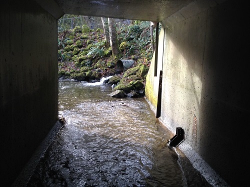
If culverts under a busy state road are clogging a creek and preventing fish from migrating, how do you simultaneously replace the culverts, maintain traffic on the road, and protect the fish during construction?
[Above photo by WSDOT]
This riddle proved a real-life challenge for the Washington State Department of Transportation, which came up with an innovative answer – leave the culverts in place, build a new bridge somewhere else, and move the creek under it.
More than 50 years ago, the agency installed two 8-foot box culverts on State Route 3 over Chico Creek, home to the biggest chum salmon population in Kitsap County. In 2013, a federal court ruled that the abutting culverts were among 1,002 fish barriers in western Washington and ordered their removal by 2030.
The reason is that culverts create a “choke point” for fish – accumulating debris, narrowing the creek, and preventing thousands of salmon from making the annual spawning trek through the creek to the freshwater bay to lay their eggs. Above the creek, about 50,000 vehicles a day drive on SR 3, so a construction plan had to consider travel patterns of fish and motorists.
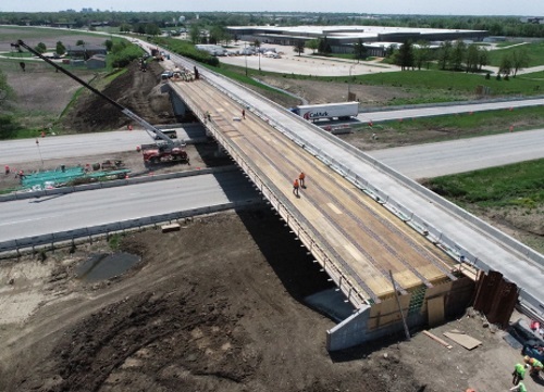
The WSDOT solution is a $58.3 million design-build project that features new bridges on SR 3 and nearby Chico Way, two realigned ramps, and two engineered creeks beneath the new bridges. The project will keep traffic and fish moving during and after construction.
An engineered waterway like this one for Coffee Creek is being built for Chico Creek. Photo by WSDOT.
Crews building a new SR 3 bridge just east of the culverts are simultaneously maintaining traffic volumes by shifting lanes toward the outside shoulders while the center portion of the bridge is constructed. Then traffic will shift again, to the inside shoulders, while the rest of the bridge is finished. Once SR 3 bridge construction is completed, crews will realign traffic lanes with the new bridge.
Meanwhile, crews are building an “engineered creek” that will realign Chico Creek to bypass the old culverts to pass under the new bridge. Construction work to redirect Chico Creek to the new channel will take place during “fish windows,” when construction work will do minimal damage to fish.
The engineered creek includes native vegetation, strategic bends, and elevation changes designed to support “every life cycle of fish,” said Doug Adamson, a WSDOT spokesman. It will feature places for fish to lay eggs and hide from predators, allowing the salmon to “naturally move” from fresh water to saltwater habitats and back again, Adamson said.
The project also includes a new bridge, two realigned ramps, and a second engineered creek at nearby Chico Way. This work will eliminate fish barriers to an unnamed tributary that feeds into Chico Creek by realigning the tributary and giving it a much wider channel under the new Chico Way Bridge.
The entire project, which will improve access to 21 miles of potential habitat, is regarded as one of the most significant fish barrier removal projects in western Washington due to the number of fish involved and because of the cultural impact to the Suquamish Tribe, whose ancestors have inhabited the area for thousands of years.
The project comes 30 years after WSDOT first created a dedicated program to remove barriers to fish under state highways. Since 1991, the agency has fixed 344 barriers, opening a total of 1,161 miles of fish habitat. “We are opening up dozens and dozens of miles for habitat for fish who couldn’t reach these areas since the highways were first built,” Adamson said. “We are making up for mistakes made in the past. We are working to rectify those mistakes to improve the habitat for native fish.”
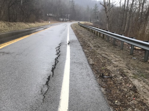
A landslide repair project currently underway on SR 60 in Morgan County, Ohio, is illustrative of dozens of similar efforts initiated by the Ohio Department of Transportation aimed at keeping small landslides from growing into larger ones.
[Above photo by the Ohio DOT]
This particular $650,259 landslide project – located between Mautz Drive, also known as Township Road 1183, and the Muskingum County line – should wrap up by December 1, the agency said.
Governor Mike DeWine (R) and Ohio DOT Director Jack Marchbanks allocated $35 million in federal funding in June to proactively deal with landslides and rockslides in eastern and southern Ohio. That money comes from $333.4 million Ohio received from the $900 billion Coronavirus Response and Relief Supplemental Appropriations Act passed in late December 2020.
State departments of transportation received $10 billion of that $900 billion to help defray the loss of motor fuel tax revenues – among other fees – resulting in part from stay-at-home orders issued to combat the COVID-19 pandemic.
“This is a wise investment. If we can address these issues early, we can avoid much costlier repairs in the future,” said Gov. DeWine in a statement.
“Southeastern Ohio is prone to these types of hazards and this effort allows us to minimize the cost and inconvenience to addressing them,” Marchbanks added.
Landslide and rockslide highway repairs can cost millions of dollars and can take anywhere from weeks to months to complete.
There are broader economic impacts from landslide/rockslide blockage of highways as well. A 34-page study conducted by HDR and Decision Economics for the Appalachian Regional Commission in 2010 found that closures of I-40 and US-64 through Tennessee due to rockslides and resulting travel detours imposed $197 million in economic costs on the surrounding area due to extra travel time and additional vehicle wear and tear.
A pair of reports – one from the U.S. Department of Transportation and the other from the Government Accounting Office – highlight the increased focus the federal government is placing on climate change and resiliency within transportation infrastructure projects.
[Above photo by the Illinois DOT]
USDOT Secretary Pete Buttigieg noted in a statement that his agency’s new 26-page Climate Action Plan “will help ensure that our transportation infrastructure, policies, and programs will be more resilient to the climate impacts already facing our country.”
That plan calls for USDOT to incorporate resilience factors into its grant-making programs, enhance resilience through the project planning and development process, and improve research on resilience. That plan also calls for USDOT to “ensure resiliency” of its facilities and operational assets while also ensuring the availability of “climate-ready services and supplies.”
Meanwhile, the GAO issued a report in late September that offered 10 options to “further enhance the climate resilience of federally funded roads” via several resiliency initiatives.
However, GAO did note in its report that such initiatives could create unintended difficulties. For example, adding climate resilience requirements to formula grant programs could compel action but complicate states’ efforts to use federal funds, the agency said.
Despite that, GAO’s report stressed that U.S. transportation infrastructure needs resiliency improvements to ward off the potentially costly impacts of climate change.
“If U.S. roads aren’t built to withstand changes in the climate, they may be unsafe routes for emergency evacuations and expensive to fix after a disaster,” GAO said in its report. “Climate-related damages to paved roads may cost up to $20 billion annually by the end of the century.”
Many state departments of transportation are already incorporating more resiliency elements into their transportation projects to ward off the climate impacts noted by GAO.
For example, Ed Sniffen – deputy director for highways at the Hawaii Department of Transportation – noted that his agency views “resilience” as a way to not only make infrastructure more robust and last longer, but save money as well.
“We’re making sure resiliency is built right into our project planning processes,” he explained during a panel discussion at the 2021 virtual American Association of State Highway and Transportation Officials Washington Briefing in March.
“But we also view it as a way to save on cost. For example, on one project, instead of re-stabilizing slope prone to rockfalls, we extended a tunnel to better protect the road,” Sniffen said. “That cost us $20 million versus $150 million to stabilize the slope.”
Margaret Anderson Kelliher, the commissioner of the Minnesota Department of Transportation, stressed that each state needs to look at the specific severe weather events that affect their areas so they can tailor infrastructure designs appropriately to maximize resilience.
Where Minnesota is concerned, she said her agency also often considers a “step back” where infrastructure is concerned – for example re-routing low volume roads away from areas prone to flooding rather than rebuild them.
“It is not always about building back better with infrastructure,” Anderson Kelliher said. “Often we need to plan whether it should be there in that location in the first place. That’s why we are really trying to pilot using ‘climate resilience’ in our corridor plans and how to support emergency repairs going forward.”
The Oklahoma Department of Transportation recently announced the 14 winners of its annual “Trash Poster” calendar contest. The original artwork of those 14 kindergarten through 12th-grade students highlighting the consequences and negative impacts of littering will adorn a free 2022 calendar distributed by the agency while supplies last.
[Above image via the Oklahoma DOT]
The Oklahoma DOT sponsors this yearly contest in collaboration with 14 partners including the Oklahoma Department of Environmental Quality, Oklahoma Turnpike Authority, Oklahoma Department of Public Safety, the Oklahoma Highway Patrol, and the Oklahoma Highway Safety Office.
The 14 contest winners will receive a monetary award, a T-shirt and facemask with their design, a laminated copy of their poster, and a state legislative citation of congratulations. The teachers of the winning students will receive a monetary award for classroom supplies and a two-day stay voucher to an Oklahoma state park courtesy of the Oklahoma Department of Tourism and Recreation, the Oklahoma DOT said.
“We continue to be amazed by the quality of art we receive from our state’s gifted students and their passion for a healthy, cleaner environment,” said Melody Johnson, Oklahoma DOT’s beautification coordinator, in a statement.
“Their work continues to inspire us in our mission to end littering across Oklahoma. Thank you to all the students for their submissions and to their wonderful teachers for including this important public messaging in their classrooms,” she added.
The agency noted that it spends nearly $6 million annually to combat litter along state highways and interstates while the Oklahoma Turnpike Authority spends an additional $1.5 million yearly to clean up trash strewn along the state’s toll road – totals that do not include the hundreds of volunteer hours spent picking up litter across the state every year.
State departments of transportation across the country are engaged in a variety of anti-litter outreach and cleanup efforts to remove trash and debris strewn along state roadways.
The California Department of Transportation recently launched a new public awareness campaign today dubbed “Let’s Change This to That” to help reduce the amount of litter and other pollutants on highways that end up in California’s water system.
Using visual comparisons of dirty and pristine roadsides and landscapes, the campaign encourages Californians to pitch in to keep highways clean and our water drinkable, swimmable and fishable.
Caltrans also recently released a video detailing the progress of its newly established $1.1 billion Clean California program that is tackling the state’s litter problems. Using before-and-after footage from Clean California events throughout the state, the video shows how Caltrans programs are clearing trash, removing graffiti, and clearing overgrown vegetation to help beautify the state’s roadsides.
Meanwhile, the North Carolina Department of Transportation said its crews, contractors, and volunteers had collected more than 10 million pounds of litter from roadsides by the end of September – close to breaking the state’s record for litter collection set in 2019.
That announcement came on the heels of the two-week Fall Litter Sweep, which saw more than 418,000 pounds of roadside litter picked up statewide. NCDOT estimates its litter removal efforts for 2021 should exceed the 2019 record of 10.5 million pounds sometime in October.