The Utah Department of Transportation is using Light Detection and Ranging or LiDAR technology as a design tool to improve safety at intersections, specifically for pedestrians and bicyclists.
[Above image by Utah DOT]
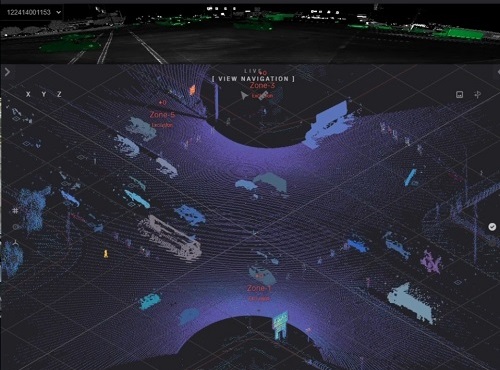
LiDAR is a remote sensing system that uses light in the form of a pulsed laser to measure variable distances to generate precise three-dimensional or 3D information. In Utah DOT’s case, traffic engineers are using LiDAR to recreate an entire intersection – including vehicle, pedestrian, and cyclist movement – in 3D; providing a complete view of an intersection, including several hundred feet in each direction.
That allows the agency’s traffic engineers to track all movements at intersections and identify areas for safety countermeasures.
Mark Taylor, Utah DOT’s traffic signal operations engineer, pointed out that the LiDAR system also captures data on red light runs, “near miss” situations, jaywalking, typical pedestrian pathway movements, and other key traffic movements.
“We are always looking at ways to use emerging technology to increase safety on our roads,” he said in a statement. “This technology will help us pinpoint why and where safety issues are occurring.”
[Editor’s note: The Utah DOT received an award for this intersection safety improvement effort from the U.S. Department of Transportation in January.]
For example, Taylor said LiDAR data will help Utah track “high frequencies” of near-miss crashes that, in the past, has been hard to track with real data, as well as “green light” times that are too short. “These, and countless other safety solutions, will be made possible through the patterns that LiDAR illuminates,” he explained.
Utah DOT has installed LiDAR technology in several Salt Lake areas and is also testing LiDAR capabilities in conjunction with connected vehicle technology at two Provo locations—another area where pedestrians and cyclists are vulnerable.
“The more we can get cars talking to our roads, the safer we will all be,” noted Blaine Leonard, Utah DOT’s transport technology engineer. “We’re hoping this LiDAR data will be another key component of this new connected future.”
Utah DOT added that it is working with Panasonic in further developing this technology package and is using part of a $20 million grant issued by the Federal Highway Administration in June to expand this concept at other locations beyond Provo.
Other state departments of transportation are also using LiDAR in a variety of high-detail mapping exercises.
For example, in June 2023, the Indiana Department of Natural Resources called upon the Indiana Department of Transportation for help “mapping” a historic water-powered grist mill at Spring Mill state park in Mitchell, IN, prior to the structure’s renovation.
The historic grist mill is located in the state park’s Pioneer Village – founded in 1814 – which contains 20 historic buildings to explore. The centerpiece is the spring-fed, three-story limestone grist mill, built in 1817, that still grinds corn today (though only for demonstration purposes) to produce cornmeal. INDOT noted that the last renovation of this grist mill occurred in 1930.
INDOT’s Land & Aerial Survey Office collected aerial imagery, light detection and ranging or LiDAR data, and other information on the grist mill via drone to create a three dimensional or 3D rendering of the building and water flume, including a fly-through video; a scaled and georeferenced point cloud of the mill building and water flume; and a publicly sharable link to an online geographic information system that features the 3D rendering and panoramic images.
And, in January 2022, the Mississippi Department of Transportation began using LiDAR-equipped aerial drones to help improve the efficiency and safety in the construction and maintenance of road projects statewide. Those drones take measurements and map out road construction projects while minimizing the exposure of ground crews to traffic, the agency said.