Reports Highlight Growing Federal Focus on Resiliency

A pair of reports – one from the U.S. Department of Transportation and the other from the Government Accounting Office – highlight the increased focus the federal government is placing on climate change and resiliency within transportation infrastructure projects.

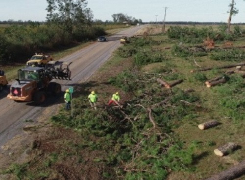
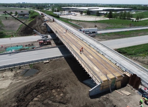
[Above photo by the Illinois DOT]

USDOT Secretary Pete Buttigieg noted in a statement that his agency’s new 26-page Climate Action Plan “will help ensure that our transportation infrastructure, policies, and programs will be more resilient to the climate impacts already facing our country.”

That plan calls for USDOT to incorporate resilience factors into its grant-making programs, enhance resilience through the project planning and development process, and improve research on resilience. That plan also calls for USDOT to “ensure resiliency” of its facilities and operational assets while also ensuring the availability of “climate-ready services and supplies.”

Meanwhile, the GAO issued a report in late September that offered 10 options to “further enhance the climate resilience of federally funded roads” via several resiliency initiatives.

However, GAO did note in its report that such initiatives could create unintended difficulties. For example, adding climate resilience requirements to formula grant programs could compel action but complicate states’ efforts to use federal funds, the agency said.

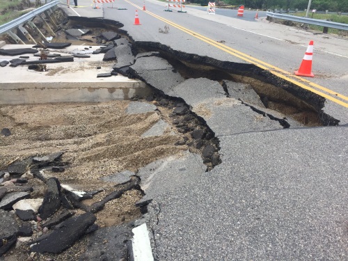
Despite that, GAO’s report stressed that U.S. transportation infrastructure needs resiliency improvements to ward off the potentially costly impacts of climate change.

“If U.S. roads aren’t built to withstand changes in the climate, they may be unsafe routes for emergency evacuations and expensive to fix after a disaster,” GAO said in its report. “Climate-related damages to paved roads may cost up to $20 billion annually by the end of the century.”

Many state departments of transportation are already incorporating more resiliency elements into their transportation projects to ward off the climate impacts noted by GAO.

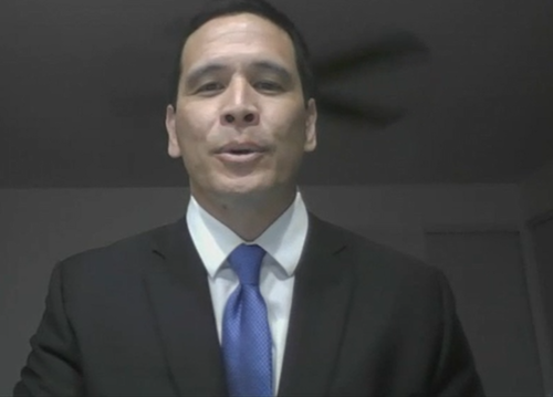
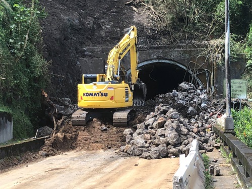
For example, Ed Sniffen – deputy director for highways at the Hawaii Department of Transportation – noted that his agency views “resilience” as a way to not only make infrastructure more robust and last longer, but save money as well.

“We’re making sure resiliency is built right into our project planning processes,” he explained during a panel discussion at the 2021 virtual American Association of State Highway and Transportation Officials Washington Briefing in March.

“But we also view it as a way to save on cost. For example, on one project, instead of re-stabilizing slope prone to rockfalls, we extended a tunnel to better protect the road,” Sniffen said. “That cost us $20 million versus $150 million to stabilize the slope.”

Margaret Anderson Kelliher, the commissioner of the Minnesota Department of Transportation, stressed that each state needs to look at the specific severe weather events that affect their areas so they can tailor infrastructure designs appropriately to maximize resilience.

Where Minnesota is concerned, she said her agency also often considers a “step back” where infrastructure is concerned – for example re-routing low volume roads away from areas prone to flooding rather than rebuild them.

“It is not always about building back better with infrastructure,” Anderson Kelliher said. “Often we need to plan whether it should be there in that location in the first place. That’s why we are really trying to pilot using ‘climate resilience’ in our corridor plans and how to support emergency repairs going forward.”

TRB Report: Include Resilience in Project Benefit-Cost Analysis

A new report issued by the Transportation Research Board calls on the U.S. Department of Transportation to include resilience factors within the benefit-cost analysis or BCA for infrastructure project justifications.

[Above photo by the Ohio DOT]

TRB’s report – entitled Investing in Transportation Resilience: A Framework for Informed Choices –  also recommends that resilience be measured and assessed using an “analytic framework” that incorporates detailed inventories of existing and planned assets, such as roads, runways, bridges, docks, and rail lines. It also seeks to include resilience within assessments of the characteristics and likelihood of future natural hazards, along with predictions of the vulnerability of the assets and their critical functions to those hazards.

[Editor’s note: In a related effort, the U.S. General Accounting Office recently issued a “Disaster Resilience Framework” to serve as an analytical guide for federal actions aimed at promoting resilience to natural disasters and changes in the climate across many policy areas, including transportation.]

The report – sponsored by USDOT and undertaken by the Transportation Resilience Metrics Committee – recommends that Congress fund a further study to define the types of data that transportation agencies need for resilience analysis, identify potential sources for this data, and explore how to make that data “more suitable” for analysis.

“Storms, floods, droughts, and other natural hazards are combining with sea-level rise and other effects of climate change to disrupt the functioning of the nation’s transportations systems,” said Joseph Schofer, professor of civil and environmental engineering and associate dean at Northwestern University, in a statement.

“Investing in resilience will require us to make carefully considered choices about how we spend money today to generate benefits that may not be realized until long into the future,” added Schofer, who authored TRB’s report.

The report also stressed that to make resilience a “routine and deliberate element” of transportation investments, Congress should consider requiring all federally funded projects involving long-lived assets to undergo “well-defined” resilience assessments that account for the risks from natural disasters and changing climate conditions.

State departments of transportation are also ramping up their focus on resilience strategies.

For example, a panel of state DOT executives and managers – as well as a team leader from the Federal Highway Administration – shared their insights on infrastructure resilience via a peer exchange during the American Association of State Highway and Transportation Officials 2021 virtual spring meeting in May.

“We are seeing events such as wildfires, flooding, and hurricanes becoming more extreme and occurring more often,” explained Edwin Sniffen, deputy director of highways for the Hawaii Department of Transportation. “We are also seeing more ‘man-made’ issues, too, such as cybersecurity, terrorist attacks, and the like. So it is super important to make our [infrastructure] systems more resilient.”

Sniffen also stressed that formula funding mechanisms are critical to building more resilience into the nation’s transportation system during a hearing on May 13 before the Senate Committee on Appropriations. “When considering funding for resilience, the current core formula program eligibility could be expanded to consider resilience improvements,” he said during his testimony. “Or formula funding could be set aside to focus on resilience-related planning, coordination, and evacuation; or, a discretionary grant program for adaptation strategies could be established. [However] AASHTO generally recommends avoiding new plans, programs, and analysis processes as this increases cost and burden to state DOTs.”

State DOTs Bracing for Highly Active Hurricane Season

As forecasters predict a particularly active hurricane season for 2021, state departments of transportation from Texas to New Jersey are preparing for worst-case scenarios to help citizens get out of town if a big storm ends up heading their way.

[Above photo by the Louisiana DOTD]

The Atlantic hurricane season began on June 1 and lasts through November 30. The National Oceanic and Atmospheric Administration’s Climate Prediction Center predicts a “likely range” of six to 10 hurricanes with winds of at least 74 miles-per-hour to form this year, with three to five major hurricanes with wind speeds of at least 111 mph developing as well.

Even relatively “minor” hurricanes can cause significant damage, especially to transportation systems, as the impact of Hurricane Sally – which struck the Alabama and Florida border in September 2020 – demonstrates.

Five hurricanes made landfall in Louisiana in 2020, prompting evacuations ahead of the storms and road closures in their aftermaths. To ensure quick evacuation of citizens from low-lying, flood-prone areas ahead of such storms, the Louisiana Department of Transportation and Development has a longstanding partnership with the Mississippi Department of Transportation to activate contraflow operations for removing people from New Orleans and coastal areas rapidly.

“The pinnacle of our cooperative efforts come out during an emergency evacuation,” Louisiana DOTD Secretary Shawn Wilson explained. “This region has a very cooperative history. We were in Beaumont (Texas) last year after one of the hurricanes, and we brought in personnel from the Tennessee DOT to help us. We all help each other as the circumstances warrant.”

Photo by Louisiana DOTD

When activated, the Southeast Louisiana Evacuation Plan calls for the Louisiana DOTD and Louisiana State Police to reverse traffic on the southbound lanes on Interstates 55 and 59. Once traffic reaches the Mississippi state line, the Mississippi DOT takes over traffic control and guides the combined eight lanes of traffic well into the heart of Mississippi.

The Mississippi DOT held a contraflow drill on June 3 to practice moving equipment into place and communicating with each other along the 86 combined miles of “contraflowed” interstate lanes.

“We go through all the motions except actually closing the exits on the interstates,” said Jas Smith, Mississippi DOT’s communications director. “The intention is to quickly evacuate the New Orleans and coastal residents. We want to get them out as quickly as possible.”

The Alabama Department of Transportation also has an interstate contraflow plan ready to go during daylight hours, according to Tony Harris, the agency’s media and community relations bureau chief.

“We only contraflow Interstate 65, north of Mobile, to Montgomery,” Harris explained. “We have a deployment rehearsal where we do everything but stop traffic. It’s like a military operation with about 120 defined steps and procedures.”

The South Carolina Department of Transportation recently released an animated video that explains how its intrastate contraflow works on Interstate 26 from Charleston to Columbia.

Meanwhile, the Florida Department of Transportation recently added several new features to its 511 site along with a new mobile application to assist motorists during hurricane evacuations.

States even as far north as New Jersey are holding evacuation drills “to practice and refine response activities in the event of a major hurricane,” according to a news release from the New Jersey Department of Transportation. “This annual drill is to practice a worst-case scenario in which New Jersey shore communities would need to be evacuated in a short period of time due to a hurricane or other natural disaster,” noted Diane Gutierrez-Scaccetti, the New Jersey DOT’s commissioner. “This gives crews from the New Jersey DOT, the New Jersey Turnpike Authority, and the South Jersey Transit Authority, along with the State Police, an opportunity to test our plans and make sure our emergency personnel are able to quickly and efficiently get people out of harm’s way.”

Georgia DOT Deploys ‘Lessons Learned’ for 2021 Hurricane Season

The Georgia Department of Transportation’s state maintenance office is tapping into five years’ worth of “lessons learned” to help fine-tune its storm response capabilities ahead of the 2021 Atlantic Hurricane Season – which lasts from June 1 through November 30.

[Above photo by the Georgia DOT]

“Over the last five years, after each weather or emergency event, Georgia DOT conducted after action reviews to address key takeaways, identify gaps in operations and brainstorm best practices for moving forward,” explained Larry Barnes, Georgia DOT’s assistant state maintenance engineer of emergency operations, in a statement.

“This effort has allowed us to continue to build up resources and develop more effective weather and emergency response plans to ensure that we are able to clear roads and restore mobility to Georgians as efficiently and safely as possible,” he said.

Photo by the Georgia DOT

Some of the storm response tactics developed from those takeaways include: 

  • Each of Georgia DOT’s seven districts now features a “Chainsaw and Emergency Response” trailer stocked and ready to go for debris removal operations. 
  • A hurricane gate contract for continued maintenance on all gates statewide to ensure they are ready for contraflow operations, if needed. 
  • Upgrading the agency’s WebEOC system – originally deployed in 2015 and used by its emergency operation center – to improve incident management, resource tracking, and mapping capabilities.
  • Securing debris clean-up contractors to clear both state routes and interstates post disaster, allowing Georgia DOT forces to work more efficiently and to provide off-system assistance to counties and local municipalities who request it. 
  • Improved communications through Sonims: rugged mobile devices that more robust communication capability for in-field teams during disaster recovery operations. Sonims can also track where crews have been working resulting in more efficient clean up, the Georgia DOT said. 
  • Increasing the number of mobile message boards, barrels, and cones available for hurricane-response needs.

The Georgia DOT added that, according to the National Oceanic and Atmospheric Administration, the 2021 hurricane season is expected to be “above average” with an anticipated 13 to 20 named storms, six to 10 hurricanes, and three to five “major” hurricanes –defined as Category 3 or greater – predicted to develop over the next six months.

Pew Trust: How Flooding Impacts Maryland’s Transportation System

A recent study indicates that major flooding occurring outside designated flood zones is significantly affecting Maryland’s highways, bridges, tunnels, and other roadways. As a result, such flooding “interrupts daily life; delaying or blocking passage of emergency response vehicles and people trying to get to work or school.”

[Above photo by Jay Bock, Flickr.]

The study – entitled “Flooding Impacts on Maryland’s Transportation System and Users” by strategic consulting firm ICF with support from The Pew Charitable Trusts — examines how flooding affects nearly 15,000 lane miles of state-maintained roadways or roughly about 20 percent of Maryland’s overall lane mileage. The findings draw from data collected between 2006 and 2020 by the Maryland Department of Transportation.

The report’s researchers reviewed 2,771 flood-related incidents for which geospatial data was available and found that 78 percent occurred outside the 100- or 500-year flood zones mapped by the Federal Emergency Management Agency. Those incidents took place, on average, only about 0.3 miles from the mapped flood areas, but even so, the findings underscore that flooding is not limited to mapped zones.

The report also identified locations along state highways that are especially flood-prone, making them prime targets for infrastructure resilience or relocation investment. Data from the past 15 years shows clusters of flood incidents on state highways, including more than 100 locations with at least five flood events within about 1,000 feet of one another. Seven locations appear to be especially at risk, with at least 30 such incidents among them, the study found.

The report also shows how flooding disrupts travel, causes safety risks, and generates economic productivity losses, among other adverse consequences. Flooding of state-maintained roadways in Maryland accounts for weeks of traffic disruptions annually, averaging 1,582 hours or 66 days per a year. Although most flood-caused lane closures lasted less than four hours, 16 percent of all disruptions lasted longer than 12 hours.

The study found that those incidents affected, on average, more than 480,000 people annually. On top of that, economic impact of lost work time and delayed deliveries cost about $15 million per year in Maryland and totaled more than $230 million during the study period.

Each flood incident resulted in an average of about $80,000 in user delay costs, Pew’s researchers noted – considered “just a fraction” of the fiscal impact because it does not factor in other expenses, such as emergency response and infrastructure repairs.

Hawaii DOT’s Sniffen: Formula Funding Critical for Resilience Efforts

Formula funding mechanisms are critical to building more resilience into the nation’s transportation system, argued Edwin Sniffen (seen above), deputy director of highways for the Hawaii Department of Transportation, during a May 13 Senate Committee on Appropriations.

Appearing before the subcommittee on transportation, housing and urban development, and related agencies, Sniffen said transportation resilience is about “balancing today’s needs with the future and setting the plans and processes so that addressing adaptation is the default.”

That is why, he said, all of Hawaii DOT’s operational divisions have initiated climate adaption studies in response to ongoing and forecasted climate change.

“When your transportation systems are surrounded by water, like ours, climate adaptation is a must. However, I would like to make the argument that climate adaptation is necessary for all, regardless of their geography,” Sniffen explained in his written testimony. Yet simply moving transportation infrastructure out of “harm’s way” is neither the most practical nor economical solution.

“The 2017 ‘Hawaii Sea Level Rise Vulnerability and Adaptation Report’ forecasts one meter of sea level rise affecting the Hawaiian Islands by 2100. If we took a traditional approach of relocating transportation facilities, we would be looking at an estimated $30 billion to relocate or elevate state roads and bridges, address impacts to airports, and protect the state’s commercial harbor facilities,” he explained.

That is where resiliency comes into play, Sniffen stressed. 

“I believe that the definition of resilience is critical and should not be related simply to the ability of an asset to not fail during certain events such as a bridge strike or a category-five hurricane,” he emphasized. “Rather, it needs to involve the ability of a state department of transportation to anticipate, plan, and adapt to potential risks; withstand, respond to, or recover when an event occurs; and construct and maintain assets that decrease project vulnerability risks.”

Sniffen – who also serves as chair of the American Association of State Highway and Transportation Officials Committee on Transportation System Security and Resilience – said that traditional formula funding processes play a key role helping states implement resiliency plans.

“When considering funding for resilience, the current core formula program eligibility could be expanded to consider resilience improvements,” he said. “Or formula funding could be set aside to focus on resilience-related planning, coordination, and evacuation; or, a discretionary grant program for adaptation strategies could be established. [However] AASHTO generally recommends avoiding new plans, programs, and analysis processes as this increases cost and burden to state DOTs.”

Sniffen added that additional funding and an expedited project delivery process would “greatly aid” getting more resilience initiatives out of the theoretical stages and into practice on the nation’s streets, bridges, runways, and harbors.

“The Hawaii DOT is currently approaching building resilience into our systems using a variety of approaches, including pursuing green infrastructure such as carbon mineralized concrete and adding recycled plastics to asphalt mixes,” he noted. “Investing in resilient infrastructure on a federal level will enable us and other transportation agencies to implement better and greener infrastructure.”

State DOTs Share Resilience Strategies for Transportation Planning

A panel of state department of transportation executives and managers, as well as a team leader from the Federal Highway Administration, recently shared their insights on infrastructure resilience via a peer exchange during the American Association of State Highway and Transportation Officials 2021 virtual spring meeting.

[Above photo by the Hawaii DOT]

“We are seeing events such as wildfires, flooding, and hurricanes becoming more extreme and occurring more often,” explained Edwin Sniffen, deputy director of highways for the Hawaii Department of Transportation. “We are also seeing more ‘man-made’ issues, too, such as cybersecurity, terrorist attacks, and the like. So it is super important to make our [infrastructure] systems more resilient.”

Sniffen – who also serves as chair of the American Association of State Highway and Transportation Officials Committee on Transportation System Security and Resilience – added that “emergency response” is becoming a more crucial component of resiliency efforts at the state DOT level. “That’s one reason why we want to try and make FHWA ER [emergency relief] funding more consistent across the nation,” he explained. “Everyone is looking towards how to make things better.”

[Sniffen expanded further on Hawaii DOT’s resiliency philosophy during testimony May 13 before the Senate Committee on Appropriations.]

Michael Culp – FHWA’s team leader for sustainable transportation and resilience – noted during the exchange that his agency is “really focused on integrating resilience across the board. I would expect in the future to see more [resilience] policies coming out on all of these fronts; not just for state DOTs but for FHWA and the U.S. Department of Transportation, too.”

That includes more “technical guidance type work” and pilot projects where resiliency is concerned, he added.

“We’re seeing a ramped up focus on climate/extreme weather and how it impacts the highway system,” Culp noted, emphasizing that there is “a lot of interest” on Capitol Hill in seeing that the federal surface program integrate resilience within the nation’s transportation system.

“Resilience will also definitely have a lot of presence in federal [infrastructure] legislation, whatever it ends up looking like,” he added.

Elizabeth ‘Lizzie’ Kemp, head of the Colorado Department of Transportation’s resiliency program, noted that her agency “started down the path of resiliency planning” eight years ago in response to major flooding that occurred in 2013.

Since then, the Colorado DOT has developed a tool to calculate infrastructure risk while assessing the potential benefits of resiliency investments. “We’ve started looking at this from the planning perspective – deploying resilient designs in high risk areas where benefit costs support it,” she explained. “It is not an easy process to develop such tools, as the data are not always there. We have spent the last three or so years developing a robust tool kit to improve our resiliency decision-making in a day-to-day way. That is the key: getting better data for our tool kit and then integrating its findings into our day-to-day decision-making process.”

Yet Jennifer Carver – statewide community planning coordinator for the Florida Department of Transportation – cautioned that incorporating resilience into infrastructure planning “is not a quick thing.” It also involves all of the infrastructure-related processes within a state DOT: long-range planning, construction and design, plus maintenance.

“Over the last few years we set up a framework on how to ‘name’ resilience and point to where we are incorporating it in our infrastructure efforts,” she said. “That’s helped energize our agency around resilience and make it part of what we do. It makes every project into a resilience project.”

Gregg Brunner, director of bureau of field services for the Michigan Department of Transportation, said efforts like Florida DOT’s are vital to “bring more folks to the table” within a state DOT “from an educational standpoint in order to create awareness of the resiliency terminology.”

Developing agency-wide risk assessment and management process is the next step, he said. “It’s about breaking down risk management into two parts – agency risk, or how it impacts Michigan DOT as a whole, and then project-level risk.”

Brunner added that “agency level threats” include things that affect the department’s labor force, technology, and financial health. Project level risks, by contrast, include things like extreme weather events. “From there we develop a risk matrix: Examining likelihood of things like flooding or cyberattacks occurring in different areas around Michigan.”

Geography makes a big difference, too, he noted. For example, while six inches of snow in the Upper Peninsula region of the state would be a non-event – “business would carry on as usual,” Brunner said – six inches in Detroit would shut down the city. “Developing a risk assessment matrix is what helps us pinpoint locales with highest risk factors,” he said.

Chris Engelbrecht, assistant to the chief safety and operations officer at the Missouri Department of Transportation, stressed that planning ahead for disaster is crucial – especially when trying to build in more infrastructure resiliency. 

“The hardest time to incorporate resilience is in the disaster recovery phase – that is when we’re stressed with reopening closed roads as fast as possible,” he said. “Thus it is a struggle to bring resilience into the repair process.”

That’s why predictive tools are so important when it comes to planning resiliency improvements. “Looking at historical data does not always give us the full risk picture either,” Engelbrecht noted. “We need to look to the horizon, to examine changing weather patterns so we obtain ‘leading indicators’ before extreme events happen.”

The Minnesota Department of Transportation is already doing that to a degree, noted Tim Sexton, the agency’s assistant commissioner for sustainability and health.

“Right now Minnesota is forecasted to be the number one or two state in the nation affected by climate change; it’ll be getting warmer and wetter for us,” he said. “So the first risk we face is more flooding – and that directly impacts things like slope failures along our highway and railroad networks.

By contrast, warmer winters create more freeze and thaw cycles, which affect pavement durability. “Climate change shines a spotlight on inequities in all states,” Sexton noted. “That’s why we are adjusting resilience to be part of our long-range policy and infrastructure investment plans.”

Proposed Bill Seeks to Help States Build More Resilient Infrastructure

Sen. Tammy Baldwin, D-Wisc., and Sen. Mike Braun, R-Ind., introduced the “Rebuilding Stronger Infrastructure Act” on April 20 to ensure that resilience improvements are eligible for federal funding, while requiring the Federal Highway Administration to provide states with the guidance and tools needed to rebuild infrastructure with more resiliency.

[Above photo by the Wisconsin DOT]

“Too often, highway infrastructure is rebuilt to pre-disaster specifications, leaving roads and bridges vulnerable to another disaster and costly damage repairs,” noted Sen. Baldwin in a statement.

“As extreme weather becomes more and more frequent, we need to empower states and local communities to build stronger and more resilient roads and bridges that can withstand the next storm or natural disaster,” she said. “This reform will not only ensure we are better protecting our infrastructure, but it will also save taxpayer dollars by making sure we are building it back better.”

“The Rebuilding Stronger Infrastructure Act ensures that we are investing in making our roads and bridges resilient to severe weather events and natural disasters while saving taxpayer dollars,” added Sen. Braun – covering the cost of damage from extreme weather and natural disasters such as severe storms, floods, or hurricanes.

The proposed legislation would:

  • Require the FHWA to update its Emergency Relief Manual to include the definition of resilience and identify procedures state departments of transportation may use to incorporate resilience into emergency relief projects. The manual would also encourage the use of Complete Streets design principals and consideration of access for moderate and low income families impacted by a declared disaster;
  • Require the FHWA to develop best practices for improving resilience of projects funded by the Emergency Relief program. Best practices will be shared with division offices of the Federal Highway Administration and state departments of transportation;
  • Require the FHWA to develop and implement a process to track consideration of resilience projects as part of the Emergency Relief Program and the cost of Emergency Relief projects; and 
  • Clarifies that cost-justified resilience improvements are eligible for Emergency Relief funding.

Both the American Association of State Highway and Transportation Officials and Wisconsin Department of Transportation are supporting this bill.

“Sen. Baldwin’s Rebuilding Stronger Infrastructure Act is common-sense legislation that will save taxpayers’ dollars and prevent unnecessary disruptions to our transportation system,” noted Craig Thompson, secretary-designee for the Wisconsin DOT.  “When we identify roads and bridges that are prone to be damaged by natural disasters like flooding, it just makes sense to improve them to avoid that damage, rather than risk the disruption and expense of repairing them after they’ve been washed out,” he explained. “Sen. Baldwin’s bill will help states like Wisconsin keep our roads and bridges in good condition.”