Maine DOT Creates Offshore Wind Port Advisory Group

The Maine Department of Transportation has formed an Offshore Wind Port Advisory Group (OSWPAG) to advise it and other state officials regarding the potential development of wind port facilities, which will be integral to promoting the University of Maine’s patented floating offshore wind technology and attracting offshore wind industry investment to Maine.

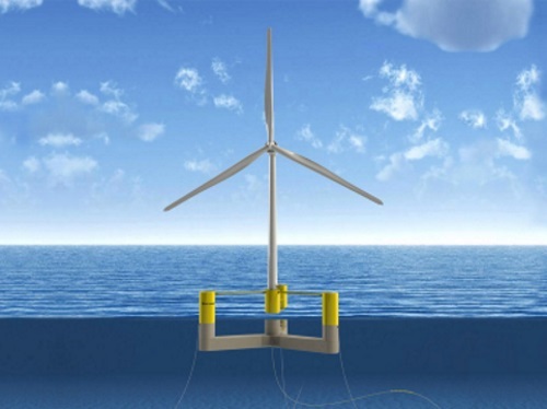
[Above image via the University of Maine]

The OSWPAG consists of 19 members representing a spectrum of local, regional, and statewide stakeholders, including representatives from the environmental, business, port and marine transportation, fishing, labor, construction, and conservation interests.

State government officials representing Maine DOT, the Governor’s Energy Office or GEO, the Governor’s Office of Policy Innovation & Future, the Maine Department of Marine Resources, and others will serve as subject matter experts to support the OSWPAG’s work. New England Aqua Ventus – the firm working with GEO to develop the floating offshore wind research array – and Maine Coast Heritage Trust, the holder of the conservation easement on the 600 acres of Sears Island reserved for conservation, will also be available to serve as technical advisors. Maine DOT said it would provide logistical and communications support for those efforts.

“Maine DOT and our collaborating state agencies want to thank the members of the Offshore Wind Port Advisory Group for agreeing to be part of this important process,” said Bruce Van Note, the agency’s commissioner, in a statement.

“We expect the stakeholders on this group to have varying perspectives and to engage in robust and thoughtful discussions regarding the potential for port development to support the rapidly growing offshore wind market,” he added. “This group’s work will provide important input as we look ahead to the ways Maine can help harness clean energy while creating jobs and strengthening our state’s economy.”

The formation of the OSWPAG is a companion effort to the Maine Offshore Wind Initiative led by the GEO, which is exploring the responsible development of floating offshore wind energy in the federal waters off the Gulf of Maine while ensuring balance with our state’s maritime industries and environment.

Maine DOT said a key component of this broader GEO initiative is the development of the Offshore Wind Roadmap, a comprehensive economic development planning process now underway. Working groups of the Roadmap include those studying energy markets, environmental and wildlife issues, supply chain, workforce development, port, and marine transportation needs, and fisheries.

Boom: Oregon DOT Uses ‘Fireworks’ to Drive Birds from Bridges

The Oregon Department of Transportation has a public outreach message for water birds who want to nest on two of their iconic bridges: Beat it.

[Above: Matt Alex, a wildlife biologist with the U.S. Dept. of Agriculture, fires a “flash pistol” to scare off birds. Photo via the Oregon DOT.]

Officially, Oregon DOT is utilizing an auditory dispersal method to relocate cormorants to facilitate infrastructure maintenance, such as inspection and painting. In practice, a technician fires a pistol that flashes, pops, and whistles. The sounds and lights chase the birds from the bridges.

“It basically is a gun-like mechanism that looks like a fireworks show,” explained Angela Beers Seydel, an Oregon DOT public information officer, in describing a test of the procedure in early March. “It whizzed, it banged, it flashed.”

Both bridges are on U.S. 101, along the Pacific coast. The 4.1-mile Astoria-Megler Bridge crosses the Columbia River and connects Oregon and Washington. It is the longest continuous truss bridge in the U.S., and painting it takes more than eight years and about $75 million.

Meanwhile, the Yaquina Bay Bridge – located about 300 miles south – is an 88-year-old arch structure built by the Public Works Administration; a depression-era federal program that also financed the Lincoln Tunnel and Hoover Dam. Conde McCullough, a renowned Oregon DOT engineer (he has his own Wikipedia page) designed the Yaquina Bay Bridge – along with 14 others along U.S. 101.

The sound-and-light program will continue through September on the Astoria-Megler Bridge and through June on the Yaquina Bay Bridge.

“These birds affect our ability to conduct inspections,” noted Don Hamilton, an Oregon DOT spokesperson. He added that those inspections occur at least every two years, but that cannot happen if birds, bird nests, or bird “guano” are on the bridge. Guano, or bird droppings, also have a corrosive effect on bridges and can be toxic to humans.

One or two technicians go on the U.S. 101 bridges every day and fire off several rounds.

Seydel said the sensory assaults take place at random times “so the birds don’t recognize a pattern. You want them to be uncomfortable to be in that area.”

Recently, Oregon DOT used propane cannons, which produce louder and deeper sounds, to successfully chase away birds from the Interstate 5 bridge over the Columbia River. Seydel said Oregon DOT might bring out those “big guns” if the pistol sounds and flashes do not work on the U.S. 101 bridges.

“There’s also the canon, if necessary,” she said. “So, whiz, bang, boom is the possibility.”

Caltrans Awards $312M for Beautification Projects

As part of Governor Gavin Newsom’s landmark $1.1 billion Clean California initiative, the California Department of Transportation recently awarded $312 million for 126 beautification projects along the state’s highway system.

[Above photo by Caltrans]

Developed in close collaboration with tribal and local governments, non-profits, and businesses, those 126 beautification projects – due to begin in April – include art installations, green space (such as parks or community gardens), and proposals that “improve safety and promote community connections.”

Designed to foster cultural connections and civic pride, Caltrans noted in a statement that those projects should generate 3,600 jobs as part of the governor’s multi-year cleanup initiative to remove trash and beautify community gateways and public areas along highways, streets, and roads. The agency added that roughly 98 percent of those beautification projects would benefit historically underserved or excluded communities.

“With Clean California projects transforming more and more sites across the state, we’re taking the next step to create enriching public spaces that serve the needs of our diverse communities and that all of us can take pride in – starting in the neighborhoods that need it most,” said Governor Gavin Newsom (D) in a separate statement. “Working together, the state and local governments are advancing unique beautification projects that will make a positive impact for years to come.”

In addition to these awards for Clean California projects along the state right-of-way, the governor announced in December 2021 the availability of almost $300 million in grants to cities and counties for local projects that “clean and beautify” neighborhood streets, parks, and transit centers throughout California.

Caltrans will review the project proposals from cities, counties, transit agencies, tribal governments, and other governmental entities, then announce grant recipients on March 1.

Over the next three years, Caltrans estimates that the “Clean California” program will remove an additional 1.2 million cubic yards, or 21,000 tons, of trash from the state highway system alone. The initiative has already resulted in 6,300 tons of litter being removed from the State Highway System and, to date, Caltrans has hired 528 new team members, including 428 maintenance workers who collect litter and perform maintenance duties like graffiti removal.

NCDOT Providing Material for Artificial Reefs

The North Carolina Department of Transportation is providing more than 1,000 tons of damaged concrete pipe to help the North Carolina Division of Marine Fisheries shore up two artificial reefs.

[Above photo by NCDOT]

NCDOT sent those discarded culverts – which accumulated over the past several years as the result of an aggressive pipe replacement program in part due to damage caused by recent hurricanes – to the Port of Wilmington for eventual deployment off of the Brunswick County coast.

N.C. Division of Marine Fisheries – part of the North Carolina Department of Environmental Quality – maintains several artificial reefs that create habitat for fish and ideal fishing sites.

It said artificial reefs create habitat for fish by creating three-dimensional structures that replicate the ecological functions of food and refuge fish and other marine life need to survive and create “crucial” spawning and foraging habitat for many commercially and recreationally important fish species.   

The fisheries division has been working with NCDOT to find “new and cost-effective uses” for scrapped concrete pipe. Using that piping to build artificial reefs for marine life along the state’s coastline in a money saver, the agency noted – eliminating $65,000 in tipping fees to dispose of it in a construction and demolition landfill.

Ken Clark, an NCDOT district engineer, said the idea for donating the pipe arose during a conference for coastal resiliency. That is when he discovered the state’s marine fisheries division could repurpose his stockpile of precast concrete, barreled-shaped pipe to augment existing artificial reefs. 

“We had considered many options on how to properly dispose of this unusable material when we formed this unique collaboration with the Division of Marine Fisheries last year,” he explained in a statement. “This program mutually benefits both state agencies.”

Other state departments of transportation are involved in similar artificial reef construction projects.

For example, in 2020, the New York State Department of Transportation began helping expand a series of artificial reefs off the shores of Long Island as part of a three-year-long multiagency effort – dumping a retired tugboat, 16 rail cars, and a streel turbine on Hempstead Reef.

“[We are] proud to work with our sister agencies on this important program, repurposing transportation materials to expand artificial reefs and support biodiversity, fishing, and tourism,” explained Marie Therese Dominguez, NYSDOT’s commissioner, in a statement at the time.

“It is another example of how [our state] is taking bold steps to protect our ecosystems and foster sustainable economic growth that will benefit current and future generations of New Yorkers,” she said.

Caltrans Approves Use of Low-Carbon Cement

The California Department of Transportation recently approved the use of low-carbon cement to help reduce the carbon footprint of the state’s transportation system.

[Above photo by Caltrans]

Known formally as Portland Limestone Cement or PLC, low-carbon cement is a blended product containing higher limestone content. Using more limestone creates less “clinker,” the basic component in nearly all types of cement, in the manufacturing process; generating less carbon dioxide as a result.

Caltrans said its road construction and maintenance projects could generate less carbon dioxide with the same high-performance standards at a slightly lower cost by using more PLC. For example, in 2017 alone, Caltrans used 325,000 tons of cement to upgrade the state highway system. Switching to low-carbon cement could potentially reduce carbon dioxide emissions by 28,000 tons a year — the equivalent of removing more than 6,000 cars off the road.

“Using low-carbon cement can cut Caltrans’ concrete-related carbon dioxide emissions annually by up to 10 percent,” noted Toks Omishakin, director of Caltrans, in a statement. “This is a big step in supporting California’s efforts to achieve carbon neutrality by 2045.”

The agency based its new low-carbon cement standards on Caltrans-funded research conducted at Oregon State University, which concluded that PLC is equally suitable for Caltrans’ construction projects as ordinary cement with a reduced carbon footprint.

Throughout the review process, Caltrans worked closely with the California Air Resources Board plus industry experts and stakeholders, such as the California Construction and Industrial Materials Association and the California Nevada Cement Association, to draft the new standard specifications.

Ohio Unveils Connected Mobility Corridor

The recently opened 33 Smart Mobility Corridor in central Ohio is a connected highway project that seeks to enhance motor vehicle safety, reduce traffic congestion, and improve fuel economy.

[Above photo by DriveOhio]

This connected highway project – overseen by InnovateOhio, which coordinates service integration among state agencies – involves the Ohio Department of Transportation, DriveOhio, the U.S. Department of Transportation, and the NW 33 Council of Governments, among others.

With a 35-mile redundant loop of fiber connectivity, the corridor includes 432 strands of available fiber, 63 roadside units, and 45 connected intersections. The route also encompasses diverse geographical and meteorological scenarios to provide a one-of-a-kind vehicle testing “ecosystem” for developing and testing smart mobility technology.

“Transportation is evolving, and mobility technology solutions that have and will be tested on the 33 Smart Mobility Corridor will save lives,” noted Jack Marchbanks, Ohio DOT’s director, in a statement. “The partnership framework we have established during this project is a model for future programs across the state, as we work to improve the quality of life for all Ohioans.”

“We know that connected and automated vehicle technology will continue to mature and scale at an ever-increasing pace,” added Howard Wood, executive director of DriveOhio, which is a division of the Ohio DOT. “As these systems are tested and refined, infrastructure plays a major role in the development cycle as mobility technology interphases with our legacy transportation system.”

“[This] corridor enables us to conduct real-world testing of our SAFE SWARM technology, which uses vehicle-to-everything communication to help mitigate collisions, improve traffic flow, increase fuel efficiency for all road users, and prepare for higher-levels of automated driving features,” said Sue Bai, chief engineer at Honda Research Institute USA, Inc.

Currently, Honda is operating over 200 connected vehicles along the corridor to understand how technology impacts the customer and realize a connected ecosystem that protects everyone sharing the road, including pedestrians, motorcycles, and bicyclists.

“This initiative is helping us develop the transportation ecosystem of the future with like-minded partners in the auto industry, government, academia, and the private sector,” Bai added.

Nevada DOT Offering “Water-Smart” Advice to State Residents

The Environmental Division of the Nevada Department of Transportation is offering state residents landscaping advice on pesticide and herbicide use as well as “water-smart practices” when conducting residential landscaping activities.

[Above photo by the Southern Nevada Water Authority]

“Most people are surprised to learn that homes can be a source of pollution,” explained James Murphy, the Environmental Division’s program manager within Nevada DOT, in a statement – noting that his division oversees disciplines such as stormwater, air quality, noise, wildlife biology, environmental engineering, and cultural resources.

“We encourage Nevada residents to take steps to avoid polluting our waterways, such as avoiding overwatering and applying pesticides, herbicides and fertilizers sparingly, with caution, and per product labeling,” he said.

Murphy explained that, in Nevada, sewer systems and stormwater drains are separate systems. Water that goes down the drain inside a home via toilet or sink goes to a wastewater treatment plant where it is treated and filtered. Conversely, water that flows down driveways and streets into gutters goes directly into a storm drain that flows untreated into lakes, rivers and streams.

Thus runoff from landscaped areas may contain fertilizers, pesticides or other materials that are harmful to lakes and streams, stressed Charles Schembre, an environmental scientist with the Nevada Division of Environmental Protection.

He explained that the most important thing residents could do to prevent stormwater contamination from landscaping activities is to avoid watering the sidewalk. Installing a buffer between the lawn and sidewalk – such as rocks, woody mulch or plants – will prevent runoff onto the sidewalk. This is a critical component in reducing runoff of pollutants into storm drains, he said.

Other tips include:

  • Use “healthy soil” practices and use organic fertilizers and pesticides sparingly; make sure to follow product label instructions.
  • Consider planting trees, seeds and plants that are native to Nevada, which require less water.
  • Use “selective” herbicide applications to target just weeds and avoid affecting desirable plant species. Avoid spraying during conditions where herbicides may drift to non-target plant species – specifically when wind speeds are greater than 15 mph.
  • Use organic mulch or other pest control methods whenever possible.
  • Install a buffer between the lawn and sidewalk to prevent irrigation runoff onto the sidewalk.
  • Pick up pet waste and dispose of it properly.
  • Use a commercial car wash or wash your car on the grass so the water infiltrates into the ground instead of spilling into storm drains.

Small Alabama Town Overcomes Barriers to Establish All-Electric Ferry

For two years, the Alabama Department of Transportation has quietly run an all-electric passenger and vehicle ferry, giving a tiny African-American community the distinction of having the only such vessel in the United States.

[Photo courtesy of the Alabama DOT.]

The story of how this unique ferry wound up in Gee’s Bend exemplifies the fundamental role transportation plays in civil rights, environmental, and social justice issues.

In the 1900s, Gee’s Bend had a hand-powered ferry – a wooden raft tethered to a cable stretched across the Alabama River. The old ferry linked Gee’s Bend – a community of about 300 people – to Camden, the county seat, where most of the grocery stores, schools, medical facilities, and government offices – including the voting registrar – are established. Without it, a 15-minute drive from Gee’s Bend to Camden turns into an hour-long journey.

“God blessed us to be able to have this ferry,” said Mary Ann Pettway, a champion African-American quilter and lifelong resident of Gee’s Bend. “That ferry is very important to all of us.”

Photo courtesy of the Alabama DOT.

However, as the civil rights movement rippled through Gee’s Bend in the 1960s, the ferry disappeared without explanation. The truth of its demise is as murky as the river it crossed, but the loss symbolized a host of injustices heaped upon the people of Gee’s Bend, who had limited access to jobs, education, medical care or emergency services.

That all began to change one night in 1993 when Hollis Curl – owner of The Wilcox Progressive Era, the county newspaper – looked across the river toward Gee’s Bend and saw smoke rising from a house fire. He knew the house was doomed and everyone inside was in danger because there was no ferry to get firefighters there in time.

“When I was a child, I remember him talking about it,” said Ethan Van Sice, the grandson of Curl, who died in 2010. “People’s houses were being burned down. He saw that smoke across the river and I think something in him clicked.”

Curl penned a front-page editorial, arguing that re-establishing the ferry would be good for both communities. The increased mobility, Curl wrote, would provide the children in Gee’s Bend with a chance at a better education and a better quality of life for everyone.

People in Camden were astonished at the newspaper’s editorial shift, but Curl’s words left them unmoved.

“It wasn’t totally received well,” Van Sice said.

Undeterred, Curl started a crusade to re-establish the ferry – and he found a willing partner in the Alabama DOT or ALDOT.

“We saw a need there,” said Josh Phillips, a public information officer for the agency. “We said, ‘We need to find a way to make this happen.’ It became a special project for ALDOT.”

Photo courtesy of the Alabama DOT.

After years of planning and some federal funding, the Alabama DOT finished the ferry in 2006, reconnecting Gee’s Bend to the rest of the world.

The ferry broke down often, however, and the service was unreliable. Ultimately, the agency decided to convert the ferry from diesel to electric power, replacing all the diesel components electric parts, lithium-ion batteries, cooling systems, and a computer and software package to orchestrate the operation.

The Alabama DOT also negotiated with two power companies to get sufficient electricity to each landing to re-charge the ferry’s massive batteries between trips.

In spring of 2019, it all came together, and the first all-electric ferry in the United States purred across the Alabama River from the Camden terminal to Gee’s Bend.

Mike Wilson of the Alabama DOT said other state departments of transportation can make the conversion to all-electric in certain situations.

“The technologies are pretty much off-the-shelf technologies, so it’s doable in the right circumstances,” he said. “Most operations that are trying to do something like this go to a hybrid boat simply because the routes are longer. Our route is such that we didn’t need to do that.”

Tim Aguirre, general manager of HMS Ferries Alabama, said the first lesson is “don’t start from scratch. There’s a lot of experience out there on this, and there are engineering firms that know how to do this.” Having the nation’s first all-electric ferry in Gee’s Bend is “a fascinating story with a neat outcome,” Aguirre said. “Ferries connect communities; they always have.”

The Ray Signs Charters to Pilot ‘Green’ Initiatives in Central Texas

The Ray – a Georgia-based transportation innovation non-profit – recently signed separate charters with the Texas Department of Transportation Austin District, Central Texas Regional Mobility Authority, and the City of Austin to pilot new technologies and “green energy solutions” for the Central Texas region. 

[Above photo via The Ray.] 

“Central Texas is a dynamic growing community with a tech-based economy and a highly educated workforce,” explained Tucker Ferguson, district engineer for TxDOT’s Austin District, in a statement.  

“The community expects government entities like TxDOT, the City of Austin, and the Mobility Authority to use new technology and innovative strategies to enhance mobility, protect the environment, improve quality of life and increase economic opportunity,” he added. “The partnership with The Ray is a great opportunity to bring additional expertise and experience to our work.” 

In Georgia, The Ray has partnered with state and industry leaders to create the world’s first sustainable highway living laboratory, and we are excited to bring our experience in transportation innovation to Central Texas,” noted Laura Rogers, director of strategic partnerships at The Ray.  

[Editor’s note: The American Association of State Highway and Transportation Officials Center for Environmental Excellence recently interviewed Allie Kelly, executive director of The Ray, as part of its Environmental Technical Assistance Program or ETAP Podcast series. Click here to listen to that interview.] 

“Focusing on infrastructure that supports future-forward transportation technology through regional collaboration allows for a seamless transition of service across jurisdictions and provides a model to scale similar initiatives across the state and nation,” she said. 

Rogers noted this new Central Texas region collaboration is focusing on “facilitating, executing, promoting and building” projects that prioritize road safety, improve infrastructure resiliency, plus protect and restore the environment.  

Those projects include but are not limited to connected autonomous vehicle infrastructure, solar-powered photovoltaic electric-vehicle or EV charging stations, and in-road dynamic wireless EV charging, she said. 

The Ray’s 501c3 nonprofit status will open additional opportunities to collaborate between the public and private sectors by acting as a bridge to accelerate project delivery while leveraging “innovative funding mechanisms,” explained Harriet Langford, president and founder of The Ray.  

By working with the various tech companies moving to Austin and those that already call Austin home, this new collaboration will bring industries together to create better results that directly benefit the citizens of Texas through job creation, resilient roads, and cleaner air, she said. 

“Much like my father Ray C. Anderson shared his model for circular business with companies around the world, The Ray is ready to scale our record of transportation innovation with states across the country,” Langford noted. “Georgia and Texas are both states with an independent streak, and together with all three agencies, The Ray will expand on our projects to create smarter and safer transportation infrastructure for Texans.”

Arizona DOT Installing New LED Highway Lights to Save Energy, Money

The Arizona Department of Transportation recently started upgrading the lighting system inside the Interstate 10 Deck Park Tunnel north of downtown Phoenix – a project that should save both energy and money.

[Photo courtesy of the Arizona Department of Transportation.]

The Deck Park Tunnel – which originally opened in August 1990 – currently uses an “old style” high-pressure sodium lighting system. The Arizona DOT is now replacing that old lighting system with 3,200 new light-emitting diode or LED fixtures; a $1.4 million project that should take several months to complete. The agency said in a statement that the new LED fixtures – expected to last well over twice as long as their sodium predecessors – should result in energy savings worth more than $175,000 per year; savings that, over time, will help pay for the cost of installing the new LED system.