Five States Help Expand U.S. Bicycle Route System

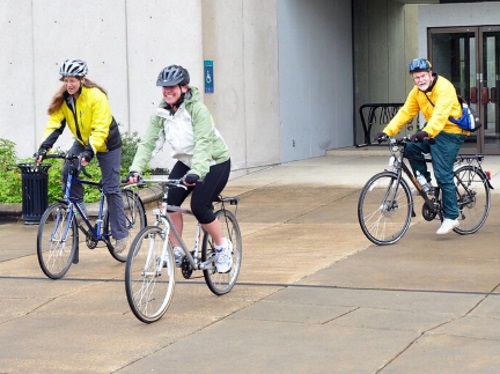
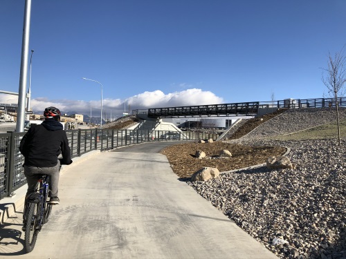
Three new U.S. Bicycle Routes in Oklahoma, Minnesota, and Delaware, along with the realignment and extension of additional routes through Indiana and Michigan, have added more than 650 miles to the U.S. Bicycle Route or USBR system. 

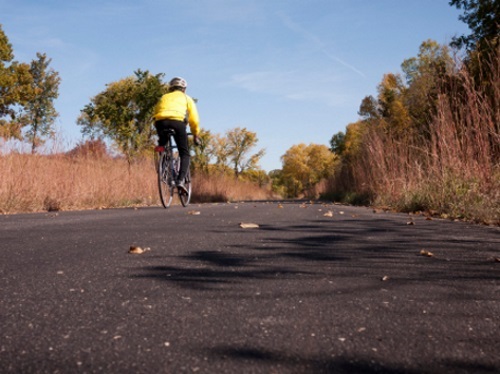
[Above photo by the Minnesota DOT]

The new routes in Oklahoma and Delaware are the first U.S. Bicycle Routes in those states, while the new route in Minnesota is its fourth. USBR 66 in Oklahoma boasts the most rideable miles of Historic Route 66, the “Mother Road.” At the same time, USBR 20 in Minnesota offers miles of off-road riding and several of the state’s 10,000 lakes, and USBR 201 through Delaware takes in historic sites and Delaware River views.

Michigan and Indiana realigned and extended existing routes based on feedback from bicyclists and local communities and due to the completion of infrastructure improvements and other projects.

“It’s been 96 years since the iconic Route 66 opened to motor vehicle traffic in the U.S.,” said Jim Tymon, executive director of the American Association of State Highway and Transportation Officials, in a statement.

“Now, cyclists can follow the historic route for more than 400 miles through Oklahoma using the newly designated USBR 66,” he added. “This latest round of U.S. Bicycle Route System designations exemplifies AASHTO’s steadfast commitment to creating active transportation facilities in rural and urban America.”

“We’re excited to coordinate this project to build a better future for bicycle travel across the United States,” said Jennifer O’Dell, executive director of the Adventure Cycling Association. “The latest designations are powerful momentum in this long-term effort.”

The U.S. Bicycle Route System is a developing national network of officially designated, numbered, and signed routes that use existing roads, trails, and other facilities appropriate for bike travel. It will eventually encompass 50,000 miles of routes and open new opportunities for cross-country travel, regional touring, and commuting by bike.

State departments of transportation develop U.S. Bicycle Routes, which AASHTO then officially designates. With the latest designations and realignments noted above, the USBR system now boasts 18,534 miles of routes in 33 states and Washington, D.C. At least 38 states are currently developing additional U.S. bicycle routes, AASHTO noted.

The nonprofit Adventure Cycling Association helps coordinates national development of the USBR system, offering technical assistance, volunteer coordination, and outreach to help states achieve official designation of routes.

In February 2021, AASHTO and Adventure Cycling signed a memorandum of understanding or MOU to formalize their 16-year partnership, which seeks to create a national bike route network that “mirrors that of the national interstate system.”

WSDOT Unveils Final Statewide Active Transportation Plan

The Washington State Department of Transportation recently unveiled its complete statewide active transportation plan to address what Governor Jay Inslee (D) called “multiple challenges” facing the state.

[Above photo by the WSDOT]

“We need a greener future for our children and grandchildren and walking and cycling represent the cleanest and greenest modes of travel,” said the governor said in a statement.

“We also need to make our system accessible for those people who can’t drive and who rely on walking or rolling to transit to get where they need to go,” Gov. Inslee added. “These multimodal journeys also contribute to our climate goals. I’m proud of our state for creating a bold plan to create safer and more accessible active transportation connections for all Washingtonians.”

WSDOT completed its plan with a two-part process, collecting public comment on part one in May 2021 and on its two final chapters in late fall 2021. The plan serves as a compass for charting the way toward a truly multimodal transportation system, the agency said

“Active transportation plays an essential role in a fully multimodal transportation system,” noted Roger Millar, WSDOT’s secretary. “Almost 30 percent of the trips we take each day are less than a mile in length, yet we often drive because there is no safe alternative. We need to make it safer for people who are just trying to cross the street or ride their bike to school or work or to the store.”

Millar – who also serves as the 2021-2022 vice president for the American Association of State Highway and Transportation Officials – added that with this plan, his state is “pointing the way to where and how we could invest in the system that works for everyone, no matter how they get around.”

Key parts of the plan include:

  • Assessment of the needs for accessible pedestrian and bicyclist facilities, highlighting safety concerns and providing the first-ever examination of state right-of-way and its suitability for active transportation.
  • New metrics for tracking and reporting progress that emphasize the importance of complete and accessible walk/bike facilities and connections to transit and other modes.
  • Calculations regarding the environmental, health and economic benefits to society when people shift trips from driving to walking or cycling.
  • Construction of a “rational approach” to prioritizing safety and operational performance needs on state highways as part of the overall networks people use to reach their destinations to help guide future transportation investment plans.
  • Incorporation of a “Safe System Approach,” which emphasizes using engineering approaches that acknowledge humans make mistakes and that crashes with greater impact force are more deadly, especially for vulnerable road users.

WSDOT said the plan notes that improvements for people walking, rolling, or cycling provide more information to drivers as well. It provides examples such as pedestrian-scale lighting and crossing visibility so drivers can see and stop in time.

It also includes designs that provide a “self-enforcing road” to help people drive at the appropriate speed for a place with a mix of destinations and people walking or cycling.

AASHTO Issues Revised Pedestrian Facilities Guide

The American Association of State Highway and Transportation Officials recently released the second edition of the Guide for the Planning, Design, and Operation of Pedestrian Facilities.

This new and completely revised edition – which supersedes the guide’s first edition, published in 2004 – provides guidance on the planning, design, and operation of pedestrian facilities along streets and highways.

The new guide focuses on identifying effective measures for accommodating pedestrians on public rights-of-way as well as appropriate methods for accommodating pedestrians, which vary among roadway and facility types.

The primary audiences for this guide include planners, roadway designers, and transportation engineers – whether at the state or local level – the majority of whom make decisions on a daily basis that affect pedestrians. This guide also recognizes the impact of land-use planning and site design on pedestrian mobility.

The new guide is available to purchase in hardcopy, as a PDF Download (either single-user, five-user, or ten-user), or in a set that includes both the hardcopy and single-user PDF Download at a discounted rate. For more information on the new pedestrian guide, visit the online AASHTO Store and search by the Item Code GPF-2 or go directly to new publication by clicking here.

State DOTs Issue Grants to Support Active Transportation Projects

The Georgia Department of Transportation and North Carolina Department of Transportation recently issued millions in grants to support a variety of alternative transportation projects across their respective states.

[Above photo by the Georgia DOT]

In partnership with the Federal Highway Administration, the Georgia DOT awarded nine Transportation Alternatives Program or TAP grants totaling over $4.5 million to support the development and/or improvement of multi-use trails, sidewalks, bicycle, pedestrian, and streetscapes in nine counties statewide.

Georgia DOT Commissioner Russell McMurry said TAP grants provide an opportunity for local governments to pursue “non-traditional” transportation related activities, with those awards comprised of 80 percent federal funds with a 20 percent local match.

“One of our most important initiatives is ensuring the safety of the public and these projects, while not traditional road improvement projects, certainly lend themselves to enhancing the safety of the pedestrians of Georgia,” he noted in a statement.

Meanwhile, NCDOT said in a statement that it is providing grants to 13 municipalities statewide with bicycle and pedestrian planning efforts.

The NCDOT Bicycle and Pedestrian Planning Grant program, now in its 19th year, helps North Carolina communities develop a comprehensive strategy for expanding bicycle and pedestrian facilities, and improving the safety of our transportation network for all users.

Jointly sponsored by the agency’s Integrated Mobility Division and Transportation Planning Division, that program has to date issued more than $7.5 million to support for 244 plans in 238 municipalities and 6 counties.

Active Transportation Council Building “Research Roadmap”

The American Association of State Highway and Transportation Officials Council on Active Transportation is planning to implement a “research roadmap” finalized in July to “prioritize and categorize” state DOT pedestrian and bicycle infrastructure investments in the near future.

[Council Chair Toks Omishakin, director of the California Department of Transportation, is second from left in the above photo with Vice-Chair Melissa Batula, deputy secretary for highway administration for the Pennsylvania Department of Transportation, at far left.]

That roadmap – developed via the National Cooperative Highway Research Program or NCHRP – seeks to focus on six specific areas:

  • Applying and integrating active transportation data into planning and operations
  • Using minimum accommodations versus alternative approaches to increase active transportation
  • Determining context-driven optimal spacing between marked crosswalks
  • Addressing barriers to integrating active transportation throughout planning and engineering practice
  • Racial and economic disparities in pedestrian and bicyclist safety
  • Speed management solutions and strategies to improve pedestrian and bicyclist safety on arterial roadways

“As you know, the Active Transportation Council was created as part of the AASHTO restructuring a few years ago, born from the institutional desire to make active transportation more prominent within the association,” explained Omishakin during a panel discussion during AASHTO’s annual meeting in San Diego.

“The Active Transportation Council has also successfully collaborated with various AASHTO committees in 2021,” he added. “For example, earlier this year, we worked with the Committee on Safety to hold a peer exchange on active transportation safety, with the discussion including data collection, asset management, plus project planning and delivery.”

Omishakin emphasized that, in terms of active transportation external engagement, AASHTO entered into a memorandum of understanding or MOU in February with the Adventure Cycling Association in terms of expanding their joint efforts to expand the U.S. Bicycle Route System or USBRS. That helped spur the designation of 18 new bicycle routes in five states in August, adding 2,903 miles to the USBRS – representing the largest addition to the USBRS to date in terms of both the number of designations and their total mileage.

“We have identified a lot of ways to help one another and work together,” Omishakin stressed during the council’s session at the AASHTO annual meeting. “We will keep both the internal and external conversations and coordination going.”

Oregon DOT Installing More Pedestrian Activated Beacons

Over the next two years, the Oregon Department of Transportation plans to install more than two dozen new rectangular rapid flashing beacons – known as pedestrian-activated beacons – to help improve safety for pedestrians along major traffic corridors in the Portland area and statewide.

[Above photo by the Oregon DOT]

Those rectangular rapid flashing beacons give people walking, rolling, or biking an additional level of control over the traffic they face, the agency explained – activating flashing lights that alert oncoming motorists to people crossing the road.

The Oregon DOT said it started using such beacons on Portland area roads a decade ago and found them to be an effective tool for improving pedestrian safety on busy traffic corridors – especially in areas with long distances between traffic signals.

They provide an additional layer of safety and assurance for anyone crossing a busy road and play an especially important role in economically disadvantaged neighborhoods, areas with higher rates of pedestrian injuries, the agency noted in a statement

In the past two years, the Oregon DOT installed 18 pedestrian-activated beacons around the region, including on Southwest Barbur Boulevard (OR 99W), Tualatin Valley Highway (OR 8), Southeast Powell Boulevard (U.S. 26), and OR 211 in Molalla. In the next few years, the agency expects to install 25 more in all three Portland-area counties, including 10 on Southeast Powell Boulevard.

Many other state departments of transportation are deploying similar technology to improve pedestrian safety as well.

For example, the Georgia Department of Transportation is using what are known as “hybrid beacons” to improve crosswalk safety for pedestrians.

Also known as the High intensity Activated crossWalK or HAWK, these beacons are pedestrian-activated warning devices located on the roadside or mounted on “mast arms” over mid-block pedestrian crossings signal both drivers and pedestrians attempting to cross a street.

Such devices are also part of a sweeping set of changes proposed by the Federal Highway Administration in late 2020 to the Manual on Uniform Traffic Control Devices or MUTCD – changes the American Association of State Highway and Transportation Officials is urging the agency to keep moving forward on.

“It has been over 10 years since the last update and, during this time, numerous advancements have been made in transportation research, technology, and practice that are not yet reflected in the manual,” AASHTO noted in a May 14 letter to FHWA. [To view AASHTO’s full comments regarding the FHWA’s proposed MUTCD revisions, click here.]

“These advancements have the potential to save lives and prevent serious injuries on the nation’s transportation system,” the group said. “Rescinding the NPA [notice of proposed amendment] and starting over, as some have suggested, would negate years of important work by FHWA and countless volunteers, and would miss the opportunity to save lives now.”

Several State DOTs Moving Ahead with Active Transportation Efforts

A number of state departments of transportation are pushing ahead with projects that support “active transportation” activity; a catch-all term that refers to infrastructure development that supports pedestrian, bicycling, and other “active” forms of mobility.

[Above photo by the Utah DOT]

The Utah Department of Transportation recently completed a $415 million I-15 Technology Corridor project that not only expanded highway capacity to support “explosive” population and business growth along the border of Salt Lake and Utah Counties but improved existing multi-use trail systems, bike lanes, and transit capacity as well.

Utah DOT said the incorporation of infrastructure “elements” supporting pedestrian and bicycling activity proved key to the overall success of the I-15 Technology Corridor project.

Prior to construction, active transportation in the area had been poor with at-grade sidewalk crossings and minimal connectivity to existing trails, the agency said. Through analysis and collaboration with multiple agencies, Utah DOT created an active transportation network with shared-use paths parallel to the frontage roads and other streets via the construction of pedestrian bridges and under-crossings.

“The Tech Corridor project was much more than just a transportation project for motor vehicles. Along with it, we now have a great looped bike and pedestrian path on each side of the freeway,” explained Kim Struthers, community development director for Lehi City, in a statement.

“This will allow easier commuting to our employment center by alternate modes of transportation. It will also serve recreational users, and allows bikers, walkers, and joggers to tie into the extensive surrounding network of trails including the Murdock Canal Trail, Jordan River Parkway Trail, and the Southern Rail Trail,” she explained. “A key component to the looped trail system is the grade-separated crossings at the I-15 at the S.R. 92 interchange, Triumph Blvd. and State Street that allow people to get across the freeway and major arterial roads in a much safer and comfortable way.” 

Meanwhile, the Oregon Department of Transportation is supporting an effort by the Portland Bureau of Transportation to install the next phase of the $13.7 million Congressman Earl Blumenauer Pedestrian and Bicycle Bridge. During the weekend of October 8, that 450,000-pound and 400-foot-long bridge – spanning I-84 – crews will lift and roll the structure into place.

Following the initial bridge placement, crews will connect the bridge to the north landing as part of the final phase of construction. When complete, the Blumenauer Bridge will connect pedestrians and people biking on NE 7th Avenue between two of Portland’s fastest-growing neighborhoods –Lloyd and the Central Eastside – and beyond. In the future, it will also serve as an important link for Portland’s Green Loop, Oregon DOT said in a statement.

When it opens in summer 2022, the agency said the bridge would also be “seismically resilient” and serve as a backup route for emergency vehicles over I-84 in the event of an earthquake. In addition to the bridge, the project includes two new public plazas and landings on the north and south sides of the bridge.

ODOT supports this effort with the city of Portland as they work to maintain a safe and modern transportation system, part of ODOT’s Strategic Action Plan.

Finally, the Washington State Department of Transportation recently invited the public to comment on the next phase of the state’s active transportation plan. WSDOT – which published part one of its active transportation plan in May – said the deadline for comments on part two of the plan is October 29.

Part one of the plan provided an assessment of the needs for accessible pedestrian and bicyclist facilities, highlighted safety concerns, and detailed the first-ever examination of state right-of-way and its suitability for active transportation. The agency said part two provides an overview of the performance metrics strategy needed to support implementation of the recommendations identified in part one of the plan.

The new phase of the plan comes during a time when motor vehicle crashes resulting in the deaths of people walking or bicycling are occurring at a higher rate in Washington State than the averages for 2010 through 2019. Those fatal crashes made up 22 percent of all traffic deaths in the state in 2020. Early in the pandemic walking and bicycling soared, and WSDOT’s multimodal transportation dashboard continues to show higher use of active transportation than in 2019.

“We analyzed state highway routes in our needs assessment because they now serve as local streets as population centers have expanded. In the past we haven’t had the data to describe the critical characteristics of these highway segments,” noted Barb Chamberlain, director of WSDOT’s Active Transportation Division, in a statement. “We’re now laying out the strategies needed to address the effects of having that mix of uses interacting,” she noted. “We’re especially focused on safety because decreasing the chance of a serious or fatal crash benefits everyone using the system, not just those who are walking or rolling and are more exposed to the consequences.”

NYSDOT Wraps Up Pedestrian Safety Improvement Projects

In late August, the New York State Department of Transportation completed work on two projects that enhance safety for pedestrians along the 90-mile corridor of State Route 25 and portions of three other roads in Nassau and Suffolk counties. 

[Above photo by NYSDOT]

Those two projects – costing $11.3 million and completed on time and under budget, NYSDOT stressed – added more than 250 new curb ramps, more than 1,800 feet of new or upgraded sidewalks, and dozens of new traffic signals and signs that will improve travel conditions for both pedestrians and motorists on some of Long Island’s busiest roadways.

“If we are serious about securing a greener future for all New Yorkers, making our streets safer and more walkable needs to be at the top of our agenda,” noted Governor Kathy Hochul (D) in a statement. “More and more people are taking to the roads again as our state continues coming back from the pandemic, and we must continue working to improve accessibility and make our streets and highways more accommodating to all modes of transportation.”

“Safety is [our] number one priority,” added Marie Therese Dominguez, NYSDOT commissioner. “Unfortunately, too often motorists are traveling at unsafe speeds or they are distracted, resulting in devastating motorist-pedestrian crashes. In addition to promoting safe driving and enforcement, these projects exemplify New York State DOT’s efforts to build safer corridors in communities across New York. A 21st Century transportation network demands that we go beyond just motor vehicles and accommodate all modes of transit so that communities continue to prosper and grow.”

The first of those projects – an $8.6 million initiative along State Route 25 that added approximately 300 new pedestrian safety enhancement measures, both large and small, along the entire stretch of the road from the New York City border to Orient Point – cost roughly $1 million less than the initial estimated costs. 

A second $2.7 million project – running some $600,000 less than expected – built 123 new Americans with Disabilities Act-compliant curb ramps on State Route 24 in the Town of Hempstead, State Route 25A (Main Street) in the Town of Huntington, and State Route 27 in the Town of Southampton.  That also included the construction of nearly 800 feet of new sidewalks along with the modernization of over a dozen pedestrian crossing signals and the addition of new pedestrian crossing signs.

Connecticut DOT Raising Awareness about New Pedestrian Laws

The Connecticut Department of Transportation’s Office of Highway Safety has launched a new campaign to raise awareness about a new statewide pedestrian safety law that goes into effect on October 1.

[Above photo Of Asylum Street in Hartford, CT, via Wikimedia Commons]

Dubbed the Pedestrian Rules campaign, it seeks to educate residents about how that new pedestrian safety law expands the circumstances under which motorists must yield the right-of-way to pedestrians at marked and unmarked crosswalks not controlled by traffic signals or police officers.  

Currently, a driver must yield to a pedestrian, slowing or stopping as necessary, if the pedestrian has stepped off the curb or into the crosswalk. Under the new law, a driver must slow or stop as necessary if the pedestrian:

  • Is within any portion of the crosswalk.
  • Steps to the curb at a crosswalk’s entrance and indicates intent to cross by raising a hand or arm to oncoming traffic
  • Indicates intent to cross by moving any body part or extension of a body part into the crosswalk entrance, including a wheelchair, cane, walking stick, crutch, bicycle, electric bicycle, stroller, carriage, cart, or leashed or harnessed dog.

As under existing law, motorists who fail to yield at a crosswalk when required are subject to a $500 fine, the Connecticut DOT said.

Meanwhile, the act of “dooring” will also become illegal in Connecticut on October 1. That new law prohibits a person from causing physical contact between a vehicle door and moving traffic by (1) opening the door, if the moving traffic is traveling at a reasonable speed with due regard for the safety of people and property, or (2) leaving it open longer than needed to load or unload passengers.

“Across the country, we are seeing increased pedestrian fatalities and injuries,” said Joseph Giulietti, commissioner of the Connecticut DOT, in a statement.

“Nationally, we saw an unprecedented 55 percent increase in pedestrian deaths between 2009 and 2018,” he added. “And although we are seeing a small recent decrease, pedestrian fatalities recorded in 2018 and 2019 have not been this high since 1990.”

According to preliminary estimates released in June by the National Highway Traffic Safety Administration, pedestrian fatalities in 2020 totaled 6,205 – the same as 2019, the agency noted. Yet agency data indicates that the 2019 number is 44 percent higher compared to pedestrian fatalities recorded in 2010.

“This new pedestrian safety law is an important step to keep everyone safe, and ultimately save lives,” added Giulietti.

Concurrently, various states across the country are achieving significant reductions in pedestrian fatalities.

For example, while a report issued by the Governors Highway Safety Association in March showed pedestrian fatalities trended up in the first half of 2020, the report also noted how several state-directed efforts are successfully improving pedestrian safety.

That report found that pedestrian fatalities during the first half of 2020 declined in 20 states and Washington D.C. compared with the same period in 2019. Meanwhile, nine states – Alabama, Florida, Hawaii, Kentucky, Massachusetts, New York, Oklahoma, Pennsylvania, and South Carolina – witnessed double-digit percentage and numeric declines in pedestrian fatalities in the first six months of 2020 compared to the same six-month period in 2019.

Based on analysis of 2017-2020 data, Arizona has experienced two consecutive years of declining pedestrian fatalities, while Delaware and Kentucky have experienced three consecutive years of declining pedestrian deaths.

GHSA’s report noted that most pedestrian fatalities occur on local roads, in the dark, and away from intersections – suggesting the need for safer road crossings and increased efforts to make pedestrians more visible through improved lighting and other countermeasures.

New Mexico DOT Unveils Five-Year Pedestrian Safety Plan

The New Mexico Department of Transportation recently adopted a five-year pedestrian safety plan that focuses on reducing pedestrian fatalities statewide, making infrastructure improvements, launching informational pedestrian safety campaigns, plus change key policies and procedures.

[Above photo by the New Mexico DOT]

The agency said plan – formally known as the “New Mexico Pedestrian Safety Action Plan” – seeks to reverse a climb in the number of pedestrian fatalities statewide. New Mexico suffered 83 pedestrian fatalities in 2019, the highest per-capita pedestrian fatality rate in the country, with another 95 pedestrians suffering serious injuries that same year.

“We must take action and the department is committed to making pedestrians safer in New Mexico,” explained Transportation Secretary Mike Sandoval in a statement. “Comprehensive pedestrian safety isn’t just a governor’s priority, it isn’t just an NMDOT priority – it’s a country, state, county, and city priority.”

He noted that New Mexico DOT’s pedestrian safety project team developed its new five-year plan following two years of research and outreach, which included gathering internal, public, and external stakeholder input, as well as cataloging and adopting national best practices.

New Mexico DOT’s efforts reflect a larger push among state departments of transportation nationwide to reduce pedestrian fatalities and injuries.

For example, while a report issued by the Governors Highway Safety Association showed pedestrian fatalities trended up in the first half of 2020, that same report also noted how several state-directed efforts are successfully improving pedestrian safety.

GHSA’s annual Spotlight on Highway Safety report found that the U.S. pedestrian fatality rate increased 20 percent in the first six months of 2020 as speeding, distracted, and impaired driving – as well as other dangerous driving behaviors – increased during the COVID-19 pandemic.

Yet that report also found that pedestrian fatalities during the first half of 2020 declined in 20 states and Washington D.C. compared with the same period in 2019. Meanwhile nine states – Alabama, Florida, Hawaii, Kentucky, Massachusetts, New York, Oklahoma, Pennsylvania, and South Carolina – witnessed double-digit percentage and numeric declines in pedestrian fatalities in the first six months of 2020 compared to the same six-month period in 2019.