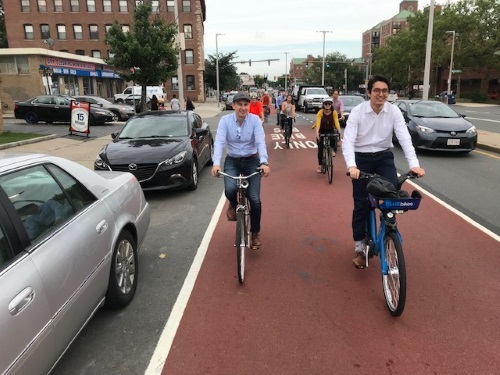
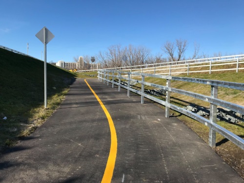
The Massachusetts Department of Transportation is providing more than $3.2 million to support 21 municipal transportation projects – including new bike-share facilities, new sidewalks, and outdoor dining areas. That money comes from the third round of Baker-Polito Administration’s Shared Winter Streets and Spaces program.
[Photo courtesy of the Massachusetts Department of Transportation.]
MassDOT noted in a statement that this program – launched in June 2020 – provides technical and funding assistance to help Massachusetts cities and towns conceive, design, and implement tactical changes to curbs, streets, and parking areas in support of public health, safe mobility, and renewed commerce, with a special focus on the particular challenges of winter.
The agency added that more than $10.2 million in state funding has been allocated for this program so far. MassDOT said its Shared Winter Streets and Spaces program provides grants as small as $5,000 and as large as $500,000 for municipalities to quickly launch changes for safer walking, biking, public transit, recreation, commerce, and civic activities. These improvements can be intentionally temporary or can be pilots of potentially permanent changes, with MassDOT particularly focused on projects that respond to the current public health crisis and provide safe mobility for children and senior citizens as well as public transportation, open spaces, and parks projects. Communities identified as at high risk for COVID-19 transmission are also given preference for winter street funding as well, the agency said.
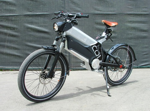
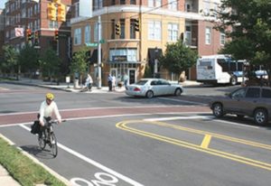
Congressional legislation introduced on February 9 by Reps. Jimmy Panetta, D-Calif., and Earl Blumenauer, D-Ore., would create a consumer tax credit to spur sales of electric bicycles for commuting and recreational purposes.
[Photo courtesy Jason Vogel, via Wikimedia Commons.]
The Electric Bicycle Incentive Kickstart for the Environment or E-BIKE Act would create a consumer tax credit that covers 30 percent of the cost of a new electric bicycle costing less than $8,000, up to a $1,500 credit.
“My legislation will make it easier for more people from all socio-economic levels to own e-bikes and contribute to cutting our carbon output,” explained Rep Panetta in a statement. “By incentivizing the use of electric bicycles to replace car trips through a consumer tax credit, we can not only encourage more Americans to transition to greener modes of transportation but also help fight the climate crisis.”
“Communities large and small are driving a bike boom [and] notably, electric bicycles are expanding the range of people who can participate and making bike commuting even easier,” noted Rep. Blumenauer, who is also the founder and co-chair of the Congressional Bike Caucus. “I look forward to working with Congressman Panetta on this important expansion of cycling opportunities.”
“The League knows life is better for everyone when more people ride bikes, and we know e-bikes make biking a more accessible and easier option for more Americans,” said Bill Nesper, executive director of the League of American Bicyclists. “We’re encouraged by congressional leadership on the E-BIKE Act, a bill that if passed will enable Americans to fight climate change and improve public health through the simple act of bicycling.”
Separately, the League of American Bicyclists recently named Tampa, FL, the number one city in the country for bicycle-friendly businesses or BFBs – a program that requires businesses to support and promote cycling to their customers, employees, and the community by providing bike parking, safety education, and promotions for retail customers who arrive by bike.
Tampa currently has 66 certified BFBs such as Tampa International Airport and Tampa General Hospital, adding nine new businesses in 2021 with six others renewing and improving their level of certification. “It’s exciting to see more and more cities such as Tampa embracing and encouraging safe, efficient multimodal transportation options,” noted Florida Department of Transportation Secretary Kevin Thibault in a statement. “[We] appreciate this recognition from the Bicycle Friendly Business program as well as their efforts to recognize businesses going the extra mile for their employees and communities.”
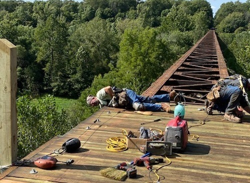
The Illinois Department of Transportation recently completed a study that outlines a variety of potential benefits from a proposed extension of the Urbana Kickapoo Rail-to-Trail project.
[Photo courtesy of Illinois Department of Transportation.]
Known as the “KRT,” the agency said in a statement that the proposed trail extension project – which includes improved access for the Carle Health System and University of Illinois campuses – would “increase opportunities for active lifestyle habits, environmental enhancements, and economic benefits.”
The 24.5-mile KRT – formerly the Chessie Seaboard Multiplier/Conrail railroad – links Urbana to Kickapoo State Park passing through St. Joseph, Ogden, Fithian, Muncie, and Oakwood. The Illinois DOT has already helped develop approximately 7.5 miles of this corridor for recreation, including hiking, biking, and other non-motorized purposes, bringing economic, transportation, and environmental benefits to these communities.
The Illinois DOT noted that it has supported work on this trail – which touches some of the most diverse ecosystems in the area, including woodland, prairie, and wetlands – via $5.3 million in funds distributed through Illinois Transportation Enhancement Program grants.
In 2019, the agency’s District 5 Office of Highways Project Implementation joined local agencies for the construction of a 1,300-foot bridge on the KRT. The bridge project – targeted for completion in the spring of 2021 – sports an 88-foot elevation, providing a “spectacular vantage point” over the North Fork Vermilion River.
The Illinois DOT noted that acquiring the land for the KRT took nearly 20 years, with the trail’s development the result of partnerships between the county conservation districts, local communities, and the state. Plans for future advancement include fundraising, land acquisition, engineering, and environmental surveys.
A report issued by the Rails-to-Trails Conservancy in October 2019 analyzed the potential economic benefits of “active transportation” investments, such as conversions of former railroad track areas to walking/biking trails.
The group’s report found that shifting short trips from driving to walking and biking via connected active-transportation infrastructure could help generate a return on investment of $73 billion to $138 billion per year in the United States if connected to public transit systems.
A key factor in its savings calculation argument is building more “synergy” between active transportation and public transportation. Currently, Rails-to-Trails said just 2.5 percent of all trips and 5 percent of work trips are made via public transit systems.
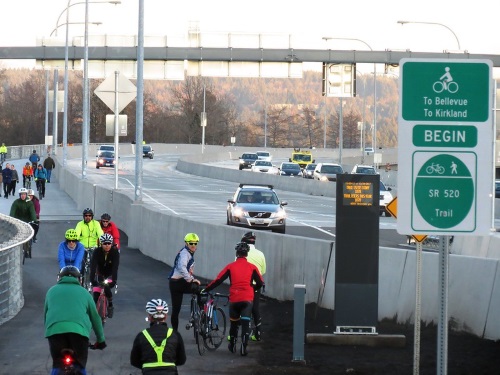
The Washington State Department of Transportation is seeking public feedback the draft of the new State Active Transportation Plan through February 15 – a new plan that reflects the fact that more people than ever are walking and bicycling statewide, according to the agency’s multimodal transportation dashboard.
[Photo courtesy of the Washington State Department of Transportation.]
The plan also focuses on the need for greater safety for pedestrians and bicyclists as a preliminary assessment of crash statistics found that 2020 fatal crashes involving such “vulnerable road users appear” to be occurring at higher rates than the averages for 2010 through 2019.
[Bicycling in particular is becoming a more frequently used transportation mode, WSDOT noted in a video.]
The New York State Department of Transportation helped complete and fully open the 750-mile long Empire State Trail – currently the nation’s longest multi-use state trail – on December 31, 2020.
[Photo courtesy of the New York State Department of Transportation.]
The Empire State Trail will be open year-round, including winter, and connects 20 regional trails to create a continuous statewide signed route.
For its part, the NYSDOT improved 170 miles of on-road bicycle route sections to enhance safety and travel on low-speed rural roadways and city streets when possible. The agency also helped install 45 gateways and trailheads along the route to welcome visitors and branded the trail with signage, interpretive panels, bike racks, and benches.
“Nearly four years ago, we announced plans to build the Empire State Trail and I am excited to announce it’s been completed on time,” explained New York Governor Andrews Cuomo (D) in a statement – adding that the trail should attract 8.6 million residents and tourists annually.
Photo courtesy of the New York State Department of Transportation
“There’s no trail like it in the nation,” he said. “Not only does it provide an opportunity to experience the natural beauty and history of New York, but it also gives New Yorkers from every corner of the state a safe outlet for recreation as we continue to grapple with the COVID-19 pandemic.”
NYSDOT Commissioner Marie Therese Dominguez noted that 58 distinct projects created more than 180 miles of new off-road trail and linked 400 miles of previously disconnected, off-road trails to eliminate gaps and ease engineering challenges such as railroad and water crossings in high traffic areas. “Completion of the 750-mile Empire State Trail is a truly historic achievement for New York State that demonstrates the intricate connection between investments in transportation infrastructure and the vitality of our communities,” she said. “This breathtaking trail will allow countless generations of New Yorkers and visitors to explore the world-renowned natural wonders and beauty of the Empire State and provide unparalleled recreational access to users of all ages and abilities – all while promoting environmental responsibility, tourism, and economic development.”
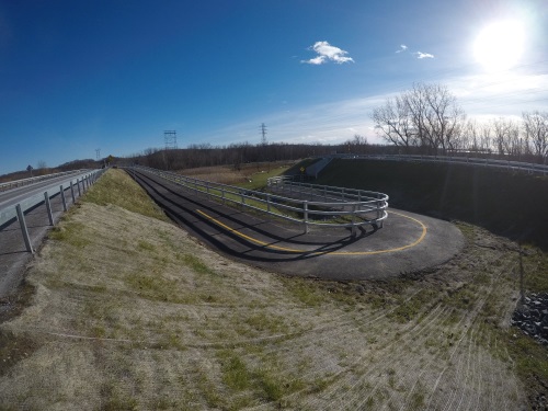
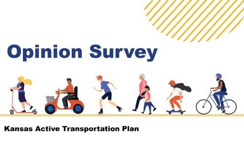
The Kansas Department of Transportation is seeking public feedback in the state’s first Active Transportation Plan or ATP in 25 years. Funding for active transportation – which refers to “human-powered” modes of transportation such as walking or cycling – is included within the state’s 10-year Eisenhower Legacy Transportation Program, or IKE, signed into law in early April.
[Photo courtesy of the Kansas Department of Transportation.]
The Kansas DOT said it is seeking public input through January 31, 2021, on its ATP via an online survey. Meanwhile, it said the planning process for the ATP will continue through 2021 and will involve national and local experts in planning, design, and safety. The final plan will also serve as a “key tool” for agency staff and local officials on how to include active transportation infrastructure when planning roads, bridges, and various improvement projects.
“We know that over the last several months, many people have discovered walking, cycling, rolling and other forms of active transportation are fun and healthy ways to get around,” noted Julie Lorenz, Kansas DOT secretary, in a statement.
“For others, active transportation has long provided an essential need, an affordable way to get to work, school, transit, the store and other destinations,” she added. “We are committed to providing transportation options that help people travel safely and conveniently – and to do that well, we need to hear from Kansans.”
“Providing access to safe, direct, continuous and pleasant routes whether driving, walking or cycling is essential for a healthy multi-modal transportation system,” added Matt Messina, Kansas DOT’s comprehensive planning unit manager. “Our intent is for Kansas residents to have a direct voice in development of the ATP.”
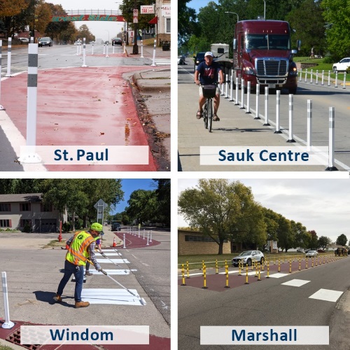
The Minnesota Department of Transportation unveiled its first Statewide Pedestrian System Plan, which provides policy and investment guidance to improve places where people walk across and along Minnesota highways.
[Photo courtesy of the Minnesota Department of Transportation.]
The agency said the plan “identifies priority areas for investments” and lays out specific strategies to improve walking availability and accessibility now and for the next 20 years to help Minnesota’s communities plan for the future. It will be accepting public feedback on this plan through January 11, 2021.
“Our state’s quality of life depends on creating safe places for people to walk—to work, to the doctor, to the grocery store, anywhere. We know safety is a priority every time you walk,” explained Margaret Anderson Kelliher, Minnesota DOT’s commissioner, in a statement. “MnDOT’s first Statewide Pedestrian System Plan serves as a framework for how we plan to meet pedestrian needs and interests in our state, and we welcome public feedback on the plan.”
The agency said it began work on its Statewide Pedestrian System Plan in February 2019, building it in part on two public engagement efforts that reached 2,700 people statewide. The Minnesota DOT said it also installed seven pedestrian safety demonstrations projects across Minnesota to highlight specific pedestrian safety measures in action, with “all of that feedback” going through an internal process of evaluation to help the agency achieve “better outcomes” for people when walking.
Photo courtesy of the Minnesota Department of Transportation
“This effort will help MnDOT identify opportunities and implement the right strategies on projects to make walking safer and more convenient for Minnesotans,” added Jake Rueter, pedestrian and bicycle planner for the agency. “The plan doesn’t tell us exactly what to do in every situation, but it provides the tools we need to make those decisions and create better places for people to walk statewide.”
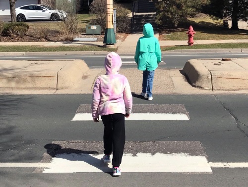
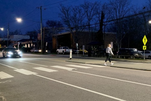
Meanwhile, on the national level, the U.S. Department of Transportation issued what it is calling a “first-of-its-kind” Pedestrian Safety Action Plan on November 23 – a plan that will be overseen by the Federal Highway Administration and National Highway Traffic Safety Administration.
“This unprecedented comprehensive safety effort is focused solely on protecting pedestrians because crossing a street should not be lethal for thousands of adults and children every year,” noted U.S. Transportation Secretary Elaine Chao in a statement – adding that USDOT’s plan will promote the expanded use of countermeasures, technology, and data-driven practices to address pedestrian fatalities and injuries.
According to NHTSA’s Fatality Analysis Reporting System, pedestrians comprised 17 percent of all traffic fatalities in 2019. In 2019 – the most recent year in which data is available – 6,205 pedestrians died in traffic crashes, which is 44 percent more compared to 2010.
The group said case studies in the report cover a diverse group of states, such as Kentucky, Louisiana, New Hampshire, Utah, and Washington State. By looking at current practices, TRB said in a blog post that state DOTs “can move forward in tailoring the data collection process to build infrastructure that will lead to more consistent and efficient planning and management of pedestrian infrastructure.”
The U.S. Department of Transportation issued what it is calling a “first-of-its-kind” Pedestrian Safety Action Plan on November 23 – a plan that will be overseen by the Federal Highway Administration and National Highway Traffic Safety Administration.
[Photo courtesy of the Federal Highway Administration.]
“This unprecedented comprehensive safety effort is focused solely on protecting pedestrians because crossing a street should not be lethal for thousands of adults and children every year,” noted U.S. Transportation Secretary Elaine Chao in a statement – noting that USDOT’s plan will promote the expanded use of countermeasures, technology, and data-driven practices to address pedestrian fatalities and injuries.
According to NHTSA’s Fatality Analysis Reporting System, pedestrians comprised 17 percent of all traffic fatalities in 2019. In 2019 – the most recent year in which data is available – 6,205 pedestrians died in traffic crashes, which is 44 percent more compared to 2010.
The USDOT noted that pedestrian fatalities are largely a phenomenon in urban areas during dark conditions, typically increasing in the fall and winter months – analysis that dovetails with findings from a report issued by the Governors Highway Safety Association in February.
The USDOT also designated October this year as the first-ever National Pedestrian Safety Month – and, concurrently, many state departments of transportation highlighted their efforts at the state level to improve pedestrian safety.
The USDOT also initiated a national series of “stakeholder discussions” in July regarding pedestrian safety, with the FHWA launching “STEP UP” –short for “Safe Transportation for Every Pedestrian” – in June to help states make roads safer for everyone.
“Reducing pedestrian fatalities is a team effort that requires collaboration between federal, state, and local transportation leaders,” noted Nicole Nason, FHWA administrator. “We need safer roads, and this plan provides a road map to get us there.” “At some point in the day, we are all pedestrians – especially right now, when everyone wants to get outside for some fresh air,” added NHTSA Deputy Administrator James Owens. “Everyone has a role to play in ensuring pedestrian safety and this Pedestrian Safety Action Plan will help communities, drivers, and pedestrians take steps to save lives.”
The U.S. Department of Transportation established October as the first-ever National Pedestrian Safety Month and, concurrently, many state departments of transportation are highlighting their efforts to improve pedestrian safety.
[Photo courtesy of the Oregon DOT.]
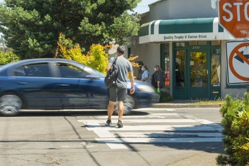
For example, the California Department of Transportation is enhancing pedestrian safety measures at high-risk locations based on traffic collision data, using what it calls a “first-of-its-kind” pedestrian safety toolbox that includes 47 countermeasures. Those include:
Signal timing enhancement and extended pedestrian crossing times.
Intersection and roadway design changes, such as adding sidewalks, curb extensions, and roundabouts or raised intersections that provide enhanced pedestrian safety in high traffic locations.
New pedestrian signs and markings, including high-visibility crosswalks, advanced stop and yield markings, or “yield to pedestrian” signs.
Caltrans is already implementing those safety measures and expects to identify further safety improvements by September 2021.
The agency noted that in California, pedestrians are 37 times more likely to be injured in a collision than any other roadway user. On top of that, between 2008 and 2017, the department said pedestrian-related incidents accounted for 19 percent of all collisions resulting in death or serious injury.
“At least two pedestrians or cyclists lose their lives on California’s transportation system each day — a number we refuse to accept or normalize,” stressed Toks Omishakin, director of Caltrans, in a statement. “Safety remains our top priority and the department will work diligently until the trend is reversed.”
Director Omashakin. Photo courtesy of Caltrans
In addition, the California Transportation Commission recently approved $100 million for projects that promote active transportation options, including the addition of 310 miles of new and repaired bike lanes; installing and repairing nearly 50 miles of sidewalk; installing nearly 3,000 new crosswalks; making 178 transit stop improvements, such as installing and improving bus shelters.
The California Office of Traffic Safety (OTS) is also providing more than $8 million in funding for programs dedicated to the safe and equal access to roads for pedestrians, including:
Complete Streets Safety Assessments to assist local agencies statewide in identifying and implementing infrastructure improvements to pedestrian safety and accessibility.
Community Pedestrian and Bicycle Safety Training programs that encourage local residents in underserved communities to develop a community action plan to improve walking and biking safety.
Coordinate Walking Tours and education outreach with health care providers and senior centers. Focus on high-collision areas for older adult pedestrians and measures to improve safe travel for older adults.
Develop “walking school buses” with groups that walk with students to school and educate students on traffic rules and best safety practices.
“Behavior change goes hand-in-hand with infrastructure improvements,” noted Barbara Rooney, director of OTS. “Safe habits by drivers and pedestrians complement a transportation system that is designed with pedestrian travel in mind.”
Meanwhile, the Utah Department of Transportation and Zero Fatalities donated 3,500 reflective drawstring backpacks to homeless service providers throughout Salt Lake County to help those experiencing homelessness stay visible to drivers during the fall, which is typically the most dangerous time of year for pedestrians.
The North Carolina Department of Transportation kicked off its 2020 Watch for Me NC awareness campaign in late September with a new twist: distributing safety tips in English and Spanish for motorists, bicyclists, and pedestrians within food delivery orders.
At the same time, North Carolina law enforcement officers are getting special training for enforcing bicycle and pedestrian safety laws as part of the program, which officially launched in 2012 to promote pedestrian safety. There are now 30 participating partner communities across the state, the North Carolina DOT said.
“It’s great to be partnering with so many communities to proactively deliver safety messages to help raise awareness and reduce fatalities among pedestrians and bicyclists in our state,” explained Heather Hildebrandt, interim director of the department’s Integrated Mobility Division, in a statement.
The Oregon Department of Transportation is using the focus on pedestrian safety to bring attention to “White Cane Safety Day,” which falls on October 15. Established by Congress in 1964, “White Can Safety Day” aims to be “a day of awareness, education, and celebration of white canes and guide dogs for independent and safe travel” for blind pedestrians.
The Oregon DOT noted in a statement that crashes between pedestrians and motor vehicles are far more likely to take place at night when it is often harder to see people walking. Between 2015 and 2017, 77 percent of such fatal crashes occurred at night. The agency added that the number of crashes involving pedestrians in Oregon increased from 849 in 2013 to 984 in 2018, the year for which the latest such data available. Concurrently, the number of pedestrians killed in a motor vehicle crash has increased from 52 in 2013 to 79 in 2018. The top driver error involved in those crashes? Failing to yield right of way to a pedestrian, the Oregon DOT said.
The COVID-19 pandemic “locked in” many places across the country in late March when a variety of local and state governments issued stay-at-home orders – many of which still remain in place to help quell the spread of the virus.
[Photo courtesy of New Jersey state government.]
Many local and state governments recognized outdoor recreational activities such as walking, bicycling, and running as “essential activities” if conducted in compliance with social distancing requirements. However, many people found they did not have safe access to areas to participate in those activities – especially as parks completely closed to the public in many areas.
As a result, state and local governments are witnessing an opportunity to increase the availability of safe active transportation space in their urban areas. Some of the measures include:
Closing certain streets to motorized vehicles. In Oakland, the city closed nearly 10% of its streets.
Expanding or creating new priority zones for cyclists and pedestrians, creating “shared spaces.”
Creating temporary or “pop-up” bike and pedestrian lanes through low-cost interventions (signage, traffic cones, and concrete barriers).
Providing equipment and finance e.g. bike commuter benefits, shower facilities at workplaces, grants to local governments that want to implement slow street initiatives.
The Oakland Slow Streets Program is one example of these types of actions. The City of Oakland Slow Streets Program supports “safe physical activity” by creating more space for physical distancing for all city residents by declaring several local roads as “slow streets.”
“Slow streets” are closed to through traffic so that people can more comfortably use low-traffic areas for physically-distant walking, wheelchair rolling, jogging, and biking all across the city. To that end, the Slow Streets: Essential Places program in Oakland extends on the original program and provides intersection improvements to support residents’ safe access to essential services such as grocery stores, food distribution sites and COVID-19 test sites.
The Massachusetts Department of Transportation is also making strides in implementing a similar idea via a Shared Streets and Spaces grant program.
The agency partnered with the Barr Foundation to provide technical assistance and support to cities and towns interested in rapidly transforming their streets to facilitate responsible public health practices. The program resulting from that program includes providing funding for more outdoor seating and recreation space for businesses, as well as safe spaces and streets blocked off for pedestrian and bicycle traffic. As of early August, the program has given out a total of $3.8 million to fund projects in 48 municipalities across Massachusetts.
Alongside of state and local “slow street” encouragement programs are efforts to expand “green street” initiatives as well – largely in terms of altering street designs to better manage storm water runoff.
In the past, storm water often flowed over the urban surface areas, collecting pollutants and other trash, until discharged untreated into creeks, rivers, lakes, and eventually oceans. Today, storm water regulations require better management of such pollutants – and one such solution involves the construction of “greener” transportation infrastructure.
For example, design methods for green streets or living streets incorporate natural components such as grassy swales, detention basins, and tree wells to manage pollutants from street runoff – methods that promote storm water capture, water conservation, and improved groundwater supplies through infiltration. Green streets also include more trees and shade, which helps improve air quality and reduce urban temperatures.
More state and local governments are recognizing the importance of green infrastructure thinking and are developing tools for transportation planners and designers.
For example, the San Diego County Green Streets technical guidance document – developed by a contract with consulting firm WSP USA in 2018 – provides directives on green designs for new streets as well as outlines for taking into account when retrofitting existing paved roads to be “greener” and manage storm water runoff better.
Many other states and organizations are seeing the positive impacts of including green and living streets in their planning processes and are developing guidelines for their transportation planners.
The District Department of Transportation, for one, established a long-range plan in 2013 to make Washington, D.C., the “greenest city in the nation.” The plan calls for increasing green infrastructure in the public right-of-way and taking actions to improve the health of the city’s waterways.
“DDOT is installing Green Infrastructure or GI as part of construction projects and in retrofit projects to reduce storm water runoff in more areas of the city,” the agency noted. “Green Street and Green Alley projects utilize GI techniques and may be constructed where watershed and infrastructure improvements are prioritized.”
The New Jersey Department of Transportation adopted a similar long-range plan in July 2019 as a “one-stop resource” for New Jersey municipalities, counties, agencies, and organizations pursuing green street strategies.
According to the agency, “green street” design elements complement efforts to create more active transportation-friendly environments by:
Creating an inviting and comfortable walking and bicycling environment by incorporating green infrastructure elements – such as street trees and rain gardens – that provide shade and remove pollutants from the air.
Minimizing flooding along streets and sidewalks that interferes with and discourages walking and bicycling.
Achieving efficiencies and cost savings when improvements are designed and constructed concurrently.
Aiding in pedestrian safety by using green infrastructure installations to slow down traffic.