Colorado DOT Works to Minimize Monsoon Impact on Roadways

As state departments of transportation along the East Coast sharpen their disaster plans ahead of the peak point of the 2020 hurricane season – with mid-Atlantic and Northeastern state DOTs already grappling with flooding and high-wind damage cause by tropical storm Isaias – the Colorado Department of Transportation is deploying strategies to combat the summer monsoon season, which typically runs from mid-July until mid-September.

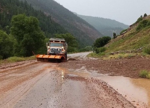
[Above photo courtesy of Colorado DOT.]

Monsoons – a term coined in the 19th century by the British in India to describe the big seasonal winds and heavy rainfall coming from the Bay of Bengal and Arabian Sea – can create flash flooding, mudslides, and rock falls that can severely damage affect Colorado roadways; causing major dilemmas for the traveling public and Colorado DOT maintenance crews.  

For example, a seven-day-long flood event in September 2013 left behind a path of destruction over an area of 2,380 square miles, causing $700 million in roadway damage. Colorado also endured a major rock fall event in 2016 during monsoon season that closed I-70 in the Glenwood Canyon for approximately two weeks. 

Those events encouraged state officials to take a deeper look into improving the resilience of Colorado infrastructure. As a result, the Colorado DOT and the Colorado Division Office of Federal Highway Administration worked to develop a plan to proactively identify and address vulnerabilities of the state’s roadway system to threats like flooding and landslides. 

As a part of that plan, the two agencies kick-started the I-70 Risk and Resilience or R&R pilot project August 2016; examining 450 miles of I-70 from the Utah border in the west to the Kansas border to identify the potential for future damage and roadway closures due to extreme weather-related events such as monsoons.

The R&R pilot project – completed in the fall 2017 – provided risk and resilience information for assets along I-70 and helped the Colorado DOT prioritize work at key locations where risk is high and resiliency is currently low. 

One of the areas identified as an important risk factor to road closures was culvert risk mitigation planning. Lizzie Kemp, Colorado DOT’s resiliency program manager, said that the study found flooding is the largest corridor risk when looking at user costs due to delays, with 80 percent of that risk due to minor culvert failure. 

She noted that Colorado has nearly 60,000 culverts that fall into this “minor” category – under 4 feet long – and so the agency first prioritized repairing and/or replacing such culverts found in poor condition along critical routes. To help with that prioritization effort, the agency uses a Geographical Information System or GIS-based Culvert Risk Assessment tool (created by Gerry Shisler for the Colorado DOT) that takes data available statewide and uses it to identify culverts, their condition, and whether they are located on “critical” roadways. 

The Colorado DOT found approximately 1,000 culverts across the state were in poor condition on critical routes and the agency than used that information to development and implement a three-step mitigation plan:

  • Step 1: Maintenance patrols complete an inspection of identified high-risk culverts and update the condition in the minor culvert database tool.
  • Step 2: Identify and document specific proposed mitigation actions for each culvert based on inspection, which could include replacing the culvert or making minor repairs.
  • Step 3: If replacement or repair is too costly or not possible, identify and document a specific operations plan which may include increased cleanout frequency and installation of technology to monitor hydraulic flows.

The Colorado DOT also found that minor culvert damage caused more than $94 million to roadway users from delays on the I-70 corridor alone; representing 80 percent of all user costs due to flooding.  As a result, the agency expects that preventing minor culvert failure during monsoon flooding events should save hundreds of millions in highway user delay costs across the state.

Caltrans Issues Final Two of 12 Climate Change Vulnerability Reports

The California Department of Transportation recently finalized and issued the last two of 12 district-based Climate Change Vulnerability Assessment Reports; studies designed to create a “comprehensive database” to help Caltrans evaluate, mitigate, and adapt to the effects of extreme weather events on the state transportation system.

[Above photo courtesy of Caltrans.]

“The completed assessments cover all 58 counties in the state and give California a comprehensive evaluation of climate change effects on the State Highway system,” explained Toks Omishakin, director of Caltrans, in a statement. “We are now integrating the findings into our planning process to better protect California’s citizens, economy and transportation investments.”

The final two reports cover Caltrans coastal district 1 and coastal district 5 and examine the potential impact of rising average temperatures, higher sea levels, storm surge, and precipitation on California’s transportation system – climate change trends that the agency said, in turn, increase incidences of flooding, drought, wildfires, coastal erosion and mudslides.

Caltrans said that understanding the impact of climate change helps the agency assess physical climate risk to the transportation system and work towards adapting infrastructure to be more “resilient” to those impacts. For example, the agency’s 12 climate reports project that by the year 2085:

  • Sea levels will rise 5.5 feet along the California coast—affecting 130 miles of State Highway by accelerating soil erosion and cliff retreat.
  • Increased severity and frequency of wildfires could threaten more than 7,000 miles of state highway.
  • High temperatures on the central coast and in the northwest part of the state could rise by 6 to 12 degrees, increasing drought and wildfire potential.

Caltrans began publishing those climate change reports in December 2018 partly in response to Executive Order B-30-15 issued by outgoing Gov. Edmund G. Brown Jr. (D), which mandated the integration of climate change analysis into transportation investment decisions.

Dual Disaster Handbook Offers Practical Guidance Amidst Chaos

Effectively managing a state transportation department is hard enough. Leading a state DOT through a crisis is tougher. But what about when two disasters hit simultaneously?

Dr. Shawn Wilson, secretary of the Louisiana Department of Transportation and Development, actually had four simultaneous disasters on his plate on Friday, June 5. In addition to transportation issues related to the ongoing COVID-19 pandemic, Wilson found himself deeply engaged in a special session of the state legislature looking at serious budget cuts that could affect transportation projects. Meanwhile, civil rights protestors in the wake of the George Floyd killing had already shut down major roadways for three straight evenings in New Orleans while a tropical storm in the Gulf of Mexico aimed itself straight for the vulnerable Louisiana coast.

Transportation Secretary Shawn Wilson with his staff. Photos courtesy Louisiana DOTD

“It’s really a juggling act and you’re juggling some very fragile crystal balls,” Wilson said.

The Louisiana DOTD’s situation is not unique, which is why the American Public Health Association and the American Flood Coalition created the “Dual Disaster Handbook” – a 25-page guide to help public officials plan “a proactive response as communities face multiple threats,” according to an APHA statement.

The handbook is a “practical publication” predicated on the assumption that spring and summer flooding will occur across the country as states are still grappling with COVID-19 related issues. However, the recommendations and checklists are relevant for any crisis management situation, APHA said.

Included in the handbook are several real-world situations that arise during a disaster, such as: the top five procurement mistakes that may lead to an audit; examples of how some agencies properly prepared for and executed plans through a disaster; and checklists of recommended actions for agency leaders who are facing simultaneous disasters.

For example, Louisiana DOTD’s Wilson said that enacting emergency storm operations and evacuation plans became “twice as complicated” because of the ongoing COVID-19 precautions.

“We’re planning for evacuation buses and mobilizing our people, but from a pandemic perspective, we’re also having to take into account screening people and providing PPE,” he explained. “Someone may not want to get on the bus because of COVID-19 and we have to prepare and train our employees to deal with that kind of situation.”

Wilson added that he welcomes the publication of the Dual Disaster Handbook and plans to distribute copies of it to his fellow committee members on the Transportation Research Board’s Committee on Transportation Resilience Metrics.

“When we’re organizing an evacuation, we usually can put at least 46 people on a bus,” he noted. “But during this pandemic, we can only have about 13 people on a bus. When you factor in families and pets, it gets complicated. Sometimes you’re looking at what is the best of the bad choices you have. Dual disasters can be messy work.”

FEMA Issues COVID-19/Hurricane Response Guidance

The Federal Emergency Management Agency has issued a 59-page document that provides Federal, state, local, tribal, and territorial or SLTT officials – along with those of private sector and non-governmental organizations (NGO) – guidance on how to respond to both the COVID-19 pandemic and hurricanes simultaneously.

“As SLTT partners continue to prepare for hurricane season and other emergent incidents, emergency managers should review and adjust existing plans – including continuity of operations (COOP) plans – to account for the realities and risks of COVID-19 in their prioritization of life-saving and life-sustaining efforts,” FEMA said in the document.” All reviews and adjustments to plans should factor-in FEMA’s planned operational posture, social distancing measures, CDC [Centers for Disease Control] guidance, and SLTT public health guidance.”

To ensure that operational decisions are made at the lowest level possible, FEMA is organizing to prioritize resources and adjudicate accordingly, if needed:

  • At the incident level, Federal Coordinating Officers (FCO – in consultation with regional Administrators – will work to address incident requirements using available resources. FCOs will proactively manage and identify risks and communicate new requirements to Regional Response Coordination Center or RRCCs as they arise.
  • At the regional level, the RRCCs will coordinate with FEMA personnel deployed to SLTT emergency operation centers and adjudicate resource requests until operational control is ready to be transitioned to the FCO at the incident level, when designated, and will adjudicate resources within their area of operation and coordinate with other RRCCs and the National Response Coordination Center (NRCC) as required.
  • At the national level, the NRCC will coordinate with the regions on requirements and adjudicate resources to address national priorities.

Hawaii DOT Studies Potential Flooding Impact on Infrastructure

The Hawaii Department of Transportation is looking at a range of studies that examine how the potential for sea level rise (SLR) due to climate change could impact transportation infrastructure. 

The most recent study, published in March of 2020 examined how direct marine inundation – which is when sea water levels rising above the current land levels – could affect Hawaii’s infrastructure but also at the impact of groundwater inundation, known as GWI.

GWI describes flooding that occurs as groundwater is lifted above the elevation of the ground surface and buried infrastructure; a difficult flooding type to manage since groundwater flooding cannot be stopped by coastal barriers such as sea walls. 

That study – conducted by researchers at the University of Hawaii at Mānoa School of Ocean and Earth Science and Technology – predicts that sea level rise will likely cause large percentages of Hawaiian land area to be impacted GWI, with Shellie Habel, lead author of the study, noting that the results “highlight the need to readjust our thinking regarding the flooding that accompanies sea level rise.”

Ed Sniffen, Hawaii DOT’s deputy director for highways and chair of AASHTO’s Committee on Transportation System Security and Resilience, estimated in a previous report that it would cost around $15 billion to protect all of the state’s coastal highways from the rising seas. The figure assumed $7.5 million for every mile of road that will need to escape erosion in the next 50 to 100 years and $40 million for every mile of bridge.

The agency began a vulnerability study in December 2019 to develop a comprehensive inventory of “potential extreme weather impacts” to Hawaii’s highway system; impacts that include GWI, SLR, and other natural disasters such as rockfalls and landslides.

Photo courtesy of Hawaii DOT

That’s in addition to a statewide assessment of SLR impacts conducted in 2017, which resulted in the Hawaii Sea Level Rise Vulnerability and Adaptation Report. That report predicted a 3.2-foot rise in global sea levels by 2100, one that could be reached as early as year 2060 under more recently published scenarios. Chronic flooding with 3.2 feet of SLR could result in approximately 25,800 acres of land in the Hawaii unusable, with roughly 34 percent of that potentially lost land containing a large amount of highway infrastructure in Maui, Oahu, and Kauai alone.

Currently, over 38 miles of major roads could be chronically flooded across the Hawaiian Islands, ranging from residential roads to sections of coastal highways such as Kamehameha Highway on Oahu. 

And much of that flooding could be from GWI rather than just direct marine inundation, thus not stoppable by traditional sea walls, which is why the Hawaii DOT is looking closely at creative engineering mitigation strategies for all flooding mechanisms for highways and bridge foundations.

Part of the agency’s flood mitigation planning is based on a study conducted for the Hawaii DOT by the University of Hawaii – called State Coastal Highway Program Report – released in August 2019. That report uses a new, detailed formula developed by the university to rank nearshore roads in order of urgency. Most of its suggested mitigation efforts focus on either “hardening” the roads and bridges or relocating them all together to higher ground. 

As a result, for the next two decades or so, the Hawaii DOT plans to strengthen and maintain the roadways as they are in place. For the future, it is also looking at elevating roadways and even relocating highways further inland and tunneling through parts of mountains to make that happen.  For instance, elevating the highway on Oahu’s Windward side could involve raising the road as high as nine feet. An alternative solution would be to relocate the highway further inland which would likely include tunneling through parts of the Koolau mountains at greater cost, the agency noted.

Recordings Available for AASHTO COIVD-19 Virtual Panels

The American Association of State Highway and Transportation Officials recently made recordings available of its weekly series of COVID-19 “virtual panels” held in April.

The AASHTO Committee on Transportation System Security & Resilience, through its Resilient and Sustainable Transportation Systems or RSTS Technical Assistance Program, sponsored those panels, which focused COVID-19 response and recovery issues faced by state departments of transportation.

The panels featured COVID-19 updates from the Federal Highway Administration, Transportation Security Administration, and Department of Homeland Security as well as from other state and local transportation agencies, followed by a question and answer session.

The panel recordings and materials can be accessed by clicking here.

AASHTO Committee Sponsors COVID-19 Panel Series

The American Association of State Highway and Transportation Officials Committee on Transportation System Security is sponsoring a series of “virtual panel discussions” to help state department of transportation leaders stay up-to-date on the latest news regarding the COVID-19 pandemic.

The panels will feature updates from the Federal Highway Administration, Transportation Security Administration, and Department of Homeland Security regarding the latest transportation implications of the COVID-19 outbreak. State DOT leaders will also get updates from other state and local transportation agencies from across the country, with an opportunity for open discussion.

The panels are also envisioned to serve as a “support group” for state DOTs facing COVID-19 emergency situations. But they are also forums for gathering and learning from the transportation impacts of the current pandemic and how they can be applied to future emergencies, including natural disasters such as hurricanes.

Another discussion thread will deal with how to improve multi-agency partnerships and emergency response efforts – especially in terms of building multi-agency ties before, and not during, emergency efforts. There will also be an emphasis on fine-tuning continuing of operations or COOP plans to help state DOTs maintain transportation systems during disease pandemics, as managing contagion outbreaks requires different protocols compared to COOP plans for wildfires, hurricanes, and the like.

The virtual panel series will be hosted weekly for the month of April. Additionally, a survey of state DOT needs or areas of interest regarding COVID-19 response and recovery will be launched at the April 8 session. Feedback collected will be used to inform subsequent sessions and additional technical assistance in response to the immediate and near-term response needs identified by state and local transportation agencies.

For registration details, please use the links below:

  • Wednesday, April 8, from 3:00 p.m. to 4:00 p.m. Eastern: click here.
  • Wednesday, April 15, from 3:00 p.m. to 4:00 p.m. Eastern: click here.
  • Wednesday, April 22, from 3:00 p.m. to 4:00 p.m. Eastern: click here.

The Ray: Fast Lane to Innovation

Imagine a highway that uses technology to track motor vehicles along an18-mile span ― that uses existing vehicle infrastructure to transmit radio data, as well as rest areas with testing zones and solar-powered charging stations.

Incorporating those features and others are part of the approach of the Georgia Department of Transportation long the said stretch of Interstate 85 via The Ray, which runs along the Ray C. Anderson Memorial Highway – so named for the late LaGrange, Georgia, native and businessman who promoted sustainability as a key aspect of future transportation projects.

The Ray – a high tech arterial roadway that lies south of Atlanta’s Hartsfield-Jackson Airport – begins at the Georgia/Alabama state line and ends in LaGrange at Exit 18. It’s a “future-forward infrastructure” project made possible by what’s known as a P4 – a public-private-philanthropic partnership.

Allie Kelly

What the state “has done with its partners in the advanced technology sector is learn from an 18-mile living laboratory that’s completely open to the public,” said Allie Kelly, executive director of The Ray. “It’s not a test track at a university, but a real-world environment that’s used by the 11.5 million drivers.”

The idea behind The Ray noted Kelly, “is to make highway transportation safer. Russell [McMurry, Georgia DOT commissioner] and I always talk about roughly 38,000 Americans who die in traffic crashes every year. They’re why we’ve worked together on various innovations” to make highway travel safer. 

One way to accomplish that goal, she explained, is to make testing easily accessible. And free.

“In 2016, we installed a drive-thru tire safety test station at Mile Marker 1 at a Federal Highway Administration rest area along The Ray’s northbound lane,” Kelly pointed out, highlighting the use of WheelRight technology at a tire safety station, which allows drivers to cruise over testing equipment “at 10 miles per hour or less”

She added that the technology evaluates tire pressure, tire tread depth, temperature, weight in motion and looks for damage on your tire sidewalls before printing out a report, all in about 10 seconds. “And it works on every vehicle type – aside from motorcycles,” Kelly noted.

She also noted that the Georgia DOT has built a dozen projects along The Ray since 2015, including the aforementioned connected vehicle infrastructure for radio data, which Kelly called “the biggest data pipeline the U.S. has ever seen, where we will have 105 million connected cars by 2022 sending out data packets at a rate of 10 times per second.”

The roadway also features a solar-powered electric vehicle charging station; a solar road called Wattways; and a megawatt solar array at the Exit 14 Diamond interchange, 40 feet from the pavement.

Russell McMurray, Georgia DOT Commissioner

Georgia DOT’s McMurray said such innovations are the result of “a case-by-case cost-sharing concept, with The Ray as a frequent financial partner,” in addition to private industry donating materials. 

He said other states are taking notice of Georgia’s approach.

“While Georgia is definitely leading the way in innovative partnerships like Georgia DOT’s partnership with The Ray, one example I can cite is the Massachusetts Department of Transportation Solar Energy Program,” McMurry noted. “[It] focuses on ground mount solar [photovoltaic] generation facilities within state highway layouts throughout Massachusetts. The goal is to create energy savings by procuring electricity at a favorable rate, generate revenue by using unused state land and support the Commonwealth’s green and clean economy.”

There are various facets to what is being accomplished via The Ray that include not only data collection and energy creation, but environmental aspects, too – such as the evaluation of different types of plants-pollinators and native species. For instance, the solar farm covers a natural habitat with native grasses and flowers, among others.

From environmental and safety standpoints, “all of the shredded tires on an interstate from blowouts and are very dangerous and they are often the byproduct of loss of life,” Kelly said. “While this effort is about safety, we’re also wasting two billion gallons of fuel every year because we can’t get our tire’s air pressure right.”

On that note, she added that “the big winners” traveling The Ray are fleets. “School buses, city transit buses and 18-wheelers coming out of ports can use every weigh station on I-85,” Kelly pointed out. “That’s how we correct those tire issues that are leading to tire failure, wasted, fuel, and dangerous crashes.” 

While made with sadness and frustration, Kelly emphasized there is hope in that observation, as well.

“The technology we need to make improvements exists,” she stressed. “We just need to start using it.”