Caltrans: Rebuilt Section of Highway 1 Could ‘Last for Centuries’

Recent hydrological studies indicate to the California Department of Transportation that it can rebuild a washed-out section of the famed Pacific Coast Highway with a massive new drainage system that would protect the roadway well past the 22nd Century.

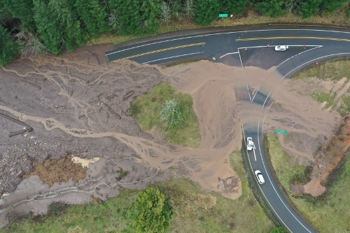
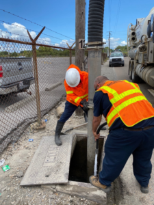
[Photo courtesy of the California Department of Transportation.]

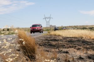
Three days of heavy rains spawned a river of mud, boulders, and fire debris on January 28 that overwhelmed a 150-foot section of the iconic Highway 1, sending it into the ocean. A five-mile section of the roadway remains closed at Rat Creek on Monterey County’s Big Sur Coast while contractors work toward an early summer re-opening.

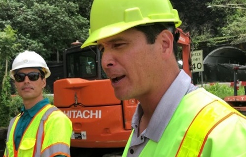
“We’re returning the road to how it was before, but with modern engineering,” said Caltrans Public Information Officer Kevin Drabinski.

The washout left a V-shaped cavity where the old fill had cradled a 66-inch culvert for Rat Creek. Contractors will re-fill, compact the material, and bore the fill to accommodate a 10.5-foot culvert before rebuilding the roadway atop the fill.

Drabinski said the new drainage system would also feature a secondary culvert and some smaller culverts closer to highway grade, providing redundancy should another major incident occur.

Photo courtesy of the California DOT

“Our hydrological studies looked at models of another large fire followed by intensive rain,” he noted. “We’re confident this new design will stand for centuries to come.”

Drabinski added that the old culvert was installed decades ago and simply couldn’t handle the swollen creek that carried boulders, fire debris, mud, and a lot of water, all fueled by 17 inches of rain in three days. A massive tree trunk jammed the culvert, turning the creek into a lake and the highway into a dam. Eventually, the water and debris overtopped and washed out the road.

Contractors are hauling away tens of thousands of cubic yards of fill material while also properly disposing of the debris left behind by the landslide, Drabinski pointed out.

“There are designated sites for the debris haul,” he said. “We have very specific rules about how we dispose of that. You can’t just haul it away. You can’t throw a mudball into the Pacific Ocean.”

Caltrans believes it can finish the work by early summer, depending on rain. Crews are working every day, “and we’re making hay while the sun shines for now,” Drabinski emphasized.

Nevada DOT Roadway Work Includes Floodplain Improvements

Department of Transportation launches the “next phase” of major reconstruction of Great Basin Boulevard and East Aultman Street in Ely, NV, the agency is placing a particular focus on floodplain improvements.

[Above graphic by Nevada DOT.]

First, to enhance drainage in preparation for the roadway improvements, Nevada DOT crews constructed nearly 2,300 feet of concrete drainage pipe and open drainage channel in 2020 in order to convey stormwater from near the Orson Avenue and North Street intersection to Murry Creek. The agency added in a statement that those drainage improvements will continue as part of the project in 2021 and, when coupled with Great Basin Boulevard drainage improvements slated for 2021 as well, the work is the first step toward reducing floodplain limits and associated flooding concerns.

The overall project – overseen by the Nevada DOT in partnership with the City of Ely – is to reconstruct deteriorated local roadways while also upgrading the city’s water and sewer facilities. Planned upgrades alongside the floodplain improvements include a “complete streets” concept to reconstruct sections of Aultman Street and Great Basin Boulevard and reconfigure lanes to provide a safer route for drivers, pedestrians, and bicyclists.

Oregon DOT Begins Work on Bridge Resiliency Project

The Oregon Department of Transportation contractor has officially started work on a series of “bridge bundles” associated with the Southern Oregon Seismic Resiliency project.

[Photo courtesy of the Oregon Department of Transportation.]

That three-year-long, $45 million project – funded by the 2017 Keep Oregon Moving legislative package – seeks to rebuild or reinforce 17 bridges and seven slopes that could be affected by the Cascadia Subduction Earthquake Zone.

The agency noted in a statement that the first “bridge bundle” being addressed within this project is an effort to strengthen Interstate 5 Exit 80 bridges near Glendale. Other bridges in this first $12.7 million “bundle” include the I-5 Exit 58 north Grants Pass interchange bridges and the nearby I-5 Hillcrest Road Bridge near milepost 57.5.

In a November 2020 blog post, the Oregon DOT noted that experts say there is a one-in-three chance a Cascadia Subduction Zone earthquake could occur within the next 50 years. The concern is that a major earthquake would isolate much of that region due to bridge damage or outright destruction, with landslides triggered by an earthquake blocking key roadways.

Photo courtesy of the Oregon Department of Transportation

Thus the idea behind the Southern Oregon Seismic Resiliency project is to “armor” key southern Oregon bridges and hillside slopes before a big earthquake strikes.

“The idea is to prepare now so the area can get back on its feet as quickly as possible, to get the region reconnected to the outside world,” explained Chris Hunter, Oregon DOT’s project manager. “How can we act strategically now to improve key bridges and known problem slopes to keep critical, life-saving goods flowing into and out of the region?“

He said Oregon DOT crews have prioritized or evaluated the most vulnerable bridges and slopes to keep the Rogue Valley connected along the I-5 corridor to Eugene and the Willamette Valley, as well as from the Rogue Valley east to the U.S. 97 corridor over Oregon 140. The plan is to quickly clear some kind of roadway connection – in the days and weeks after a subduction zone quake – even if it is a single lane or two. By keeping that connection, critical supplies can get into and out of the area, Hunter noted.

Oregon DOT: More Landslides May Occur due to Wildfires

The Oregon Department of Transportation noted in a recent blog post that landslides could increase in 2021 due to topographical damage caused by a series of devastating wildfires in 2020.

[Photo courtesy of the Oregon Department of Transportation.]

In order to track how landslide activity is influenced by wildfires, earthquakes, and climate change, the agency is in the midst of several projects that record and analyze landslide activity via ground- and aerial drone-based sensors.

[The video below, captured by an Oregon DOT drone, illustrates the type of transportation system damage that can be caused by landslides.]

To that end, Curran Mohney – senior engineering geologist with the Oregon DOT’s statewide project delivery group – is involved in an effort to monitor landslides affecting the state’s coastal highways. That project – in year four of its seven-year life – is being conducted in collaboration with students and professors from Portland State and Oregon State universities.

“Primarily what I want to know is how much time we have left for our highways in certain areas,” Mohney explained. “What’s the life span of our highways on the coast and in our stressed areas? How fast are landslides accelerating, especially with climate change drivers? How long until we lose that battle?”

He added that this project is “increasing knowledge” that will benefit the state in many ways – especially in terms of protecting its surface transportation network.

[The video below highlights the equipment and techniques deployed by the Oregon DOT and its contractors to repair roads damaged by landslides.]

For example, Mohney said every landslide has elements that indicate its approximate age: its shape and radiocarbon dating of buried animal bones and plant matter. Depending on what the research team discovers from that material helps determine whether a landslide occurred because of seismic events or just from heavy rains.

“Learning about the age and the causes of slides can help us make better decisions about our seismic lifelines or things we need to do to adapt to climate change impacts,” Mohney said.

“It’s telling us things about how and why landslides happen in certain places,” he added. “Just imagining what our issues are going to be with climate change and Cascadia [the Cascadia Subduction Zone Earthquake] – it seems insurmountable. So if we can figure out anything about where, why, how, then we can be prepared. Maybe we can go out ahead of time and make smart decisions.”

Real-Time Storm Force Prediction Model for Coastal Bridges

Dr. Teng Wu, Mr. Shaopeng Li, and Dr. Kallol Sett from the Institute of Bridge Engineering at University at Buffalo recently unveiled a new model to improve extreme damage “risk evaluation” for coastal bridges due to hurricane wave force and storm surge. 

That research focuses first on using a synthetic 10,000-year hurricane record, together with a deep neural network-based framework to predict surge and wave forces on the bridges located in specific areas. It then taps into the North Atlantic Coast Comprehensive Study or NACCS database – built to identify flood risk and mitigation strategies – which uses damage outcomes from 1,050 “synthetic hurricanes” to provide storm surge elevation and significant wave height predictions for pre-determined locations. 

All of that information is then used to determine the probability of bridge failure dependent on how susceptible a bridge deck is to being lifted off its foundation structure, those researchers said; an event known as “bridge deck unseating” that is highlighted in the video below:

Dr. Wu — associate professor at the University of Buffalo’s department of civil, structural, and environmental engineering – said during a recent presentation that the reason a new coastal bridge failure model is needed centers on the rising number of Americans living in coastal regions and their corresponding exposure to severe weather.

According to a 22-page report by the National Oceanic and Atmospheric Association, almost 40 percent of the United States population – some 127 million people — now live in coastal areas that are increasingly vulnerable to severe hurricanes.

For example, Hurricane Sandy, which made landfall in New Jersey in 2012, caused $70 billion worth of damage to densely developed areas in New Jersey and New York – with the damage to roads and bridges representing a large portion of that monetary loss.

Dr. Wu noted that the training of deep neural network focuses on damage to bridges due to bridge deck unseating as that is the most common occurrence during hurricane storm surge. 

Graphic image provided by the University of Buffalo

For example, during Hurricane Ike in 2008, some 53 bridges in the Houston/Galveston region suffered damage – and many of those damaged structures either were constructed of timber or were low-clearance water-crossing bridges. That’s why analyzing the type of bridge, bridge clearance, and the predicted storm surge and wave height for hurricane storm season in a particular coastal area can give valuable sustainability information and aid in risk planning and emergency response, Dr. Wu noted.

The University of Buffalo research included a case study on “simply supported” coastal bridges in New York State – a study that included a risk assessment for bridge deck unseating caused by storm surges and waves. Three different “clearances” of coastal bridges – which is the distance between the bottom of the bridge deck to the mean water level – were considered in that risk analysis, with the resulting case study looking at bridges in two different areas of the region: one close to the coastline and one in the Hudson River. 

That case study found that the annual damage rate to bridges decreases as the clearance increases, and bridges at the coastline are more vulnerable to storm surges and waves due to the larger surge/wave level, as expected. What the risk analysis framework does, explained Dr. Wu, is pinpoint where risk reduction strategies will be most effective – highlight those coastal bridges with the highest risk of damage from storms, allowing for more targeted mitigation planning. Dr. Wu added that this research can also help in emergency management disaster response by highlighting the infrastructure most at risk for damage and allowing for more focused traffic management and operations planning.

Universities Join Forces to Test Resiliency of Bridge Design

In a study published in the Journal of Structural Engineering, Texas A&M University and the University of Colorado-Boulder researchers have conducted a comprehensive damage and repair assessment of a still-to-be-implemented bridge design using a panel of experts from academia and industry. The researchers said the expert feedback method offers a “unique and robust” technique for evaluating the feasibility of bridge designs that are still at an early research and development phase.

[Photo courtesy of Texas A&M University.]

“Bridges, particularly those in high-seismic regions, are vulnerable to damage and will need repairs at some point,” explained Dr. Petros Sideris, assistant professor in Texas A&M’s Zachry Department of Civil and Environmental Engineering, in a blog post.

“Now the question is what kind of repairs should be used for different types and levels of damage, what will be the cost of these repairs and how long will the repairs take — these are all unknowns for new bridge designs,” he added. “We have answered these questions for a novel bridge design using an approach that is seldomly used in structural engineering.”

Most bridges are monolithic systems made of concrete poured over forms that give the bridges their shape: a design strong enough to support their own weight and other loads, such as vehicle traffic. However, Sideris said if there is an unexpected occurrence of seismic activity, such structures could crack and remedying that damage would be exorbitantly expensive.

To overcome such shortcomings, Sideris and his team – with funding from the National Science Foundation – developed a new design called a hybrid sliding-rocking bridge. Instead of a monolithic design, these “sliding rocking” bridges are made of columns containing limb-inspired joints and segments. Hence, in the event of an earthquake, the joints allow some of the energy from the ground motion to diffuse while the segments move slightly, sliding over one another rather than bending or cracking.

Yet despite potential benefits of this design, no data existed about how it would behave in real-world situations. That is where the new testing procedure developed by Texas A&M and the University of Colorado-Boulder comes into play.

“To find the correct repair strategy, we need to know what the damages look like,” Sideris said. “Our bridge design is relatively new and so there is little scientific literature that we could refer to. And so, we took an unconventional approach to fill our gap in knowledge by recruiting a panel of experts in bridge damage and repair.”

Sideris, Dr. Abbie Liel at the University of Colorado-Boulder, and their respective research teams recruited a panel of eight experts from industry and academia to determine the damage states in experimentally tested hybrid sliding-rocking segment designed columns. Based on their evaluations of the observed damage, the panel provided repair strategies and estimated costs for repair.

The researchers then used that information to fix the broken columns, retested the columns under the same initial damage-causing conditions and compared the repaired column’s behavior to that of the original column through computational investigations.

The panel found that columns built with their design sustained less damage overall compared to bridges built with conventional designs. In fact, the columns showed very little damage even when subject to motions reminiscent of a powerful once-in-a-few-thousand-years earthquake. Furthermore, the damage could be repaired relatively quickly with grout and carbon fibers, suggesting that no special strategy was required for restoration. “Fixing bridges is a slow process and costs a significant amount of money, which then indirectly affects the community,” explained Sideris. “Novel bridge designs that may have a bigger initial cost for construction can be more beneficial in the long run because they are sturdier. The money saved can then be used for helping the community rather than repairing infrastructure.”

After Bush Fire, Arizona DOT Pivots to Address Extreme Weather

When combined with fire-ravaged terrain, heavy rain creates a whole new set of highway maintenance issues.

[Above photo courtesy of Arizona DOT.]

Take California, for starters. Already in the midst of fighting several major wildfires, the state is already gearing up for potentially damaging weather/terrain scenarios that can develop due to post-fire conditions.

The California Department of Transportation dealt with one such situation three years ago when a mudslide covered portions of U.S. 50 following several heavy and wet winter storms.

In Arizona, the infamous Bush Fire in June – a human-triggered inferno that burned more than 193,000 acres of desert and vegetation in Tonto National Forest near the northeast suburbs or Phoenix ― left behind dry, rocky terrain that could not handle the rushing waters of a monsoon, since the fire melted away vital ground cover.

Thus the need arose to craft a faster response effort to address those specific conditions. As a result, the Arizona Department of Transportation created an emergency action plan that dispatches specialized highway crews that can deal with the impact that heavy rain causes on fire-scorched terrain.

Photo courtesy of Arizona DOT

Part of the good news, explained Kevin Duby, statewide road weather manager for the agency, is that the Arizona DOT created this response plan at minimal cost plan by piggybacking off an initiative of the Federal Highway Administration’s Pathfinder Program. An offshoot of the Every Day Counts innovation recognition initiative, the Pathfinder Program, keeps travelers informed, and improves safety, mobility and the movement of goods during storms via enhanced collaboration between federal, state, and local agencies.

“We utilized previous plans obtained by research on the topic, which resulted in better use of time and cost savings for taxpayers,” said Duby.

With the help of the National Weather Service or NWS, the Arizona DOT identified “areas of the watershed where problems could arise and cleaned out the drainage ditches,” Duby emphasized, noting that no major construction was necessary because cleared culverts were already in place.

“They can accommodate the water in the normal flow from the steep slopes of the Mazatzal Mountains,” he said; a range known locally as the Four Peak Mountains.

Duby added that the Arizona DOT “already had a great relationship” with NWS via several groups from within the agency, from regional districts to operations to public relations.

The depth of those collaborations proved more advantageous and timelier than originally imagined.

“The plan was completed on July 28,” Duby said. “Then about a week later we had a mudslide on State Route 188,” which connects the towns of Globe and Payson, near Roosevelt Lake, which had been identified as a flood problem area.

“We worked with NWS to come up with protocols when a storm was imminent,” Duby noted. “One was for the NWS to call our traffic operations center,” to warn representatives of the impact of the rain.

At that juncture, the traffic operations center and public information offices broadcast the information on social media. Once the flooding occurred, the Arizona DOT executed its plan and was able to respond quickly with heavy equipment in a pre-staging area. That included vehicles such as loaders, skid-steers, and backhoes; as well as barriers and portable message boards. The agency also identified alternate highway routes – notably State Route 87 and U.S. 60.

Photo courtesy of Arizona DOT

“Part of the initiative is to be proactive about getting messages out to the travelling public, with the best information we can offer,” Duby pointed out.

While he said there is also an estimated cost savings aside from avoiding the commuter delays due to the Arizona DOT’s approach, it also helped alleviate the environmental issues that are part of any major weather event.

Without the efforts of the parties involved, “taking care of that sudden real world event would have been more complicated,” explained Duby. “We had to be sure that all three Arizona DOT districts are in sync, because they all have separates staffs,” adding that Phoenix and Flagstaff – about two hours away – both have NWS offices, so keen communication between the two proved critical.

Today, the focus is on taking what’s been learned from the Bush Fire and the mudslide and use that information to prepare for the next potential weather disaster. “We’ve refined our approach and that’s making traveling safer for our citizens,” Duby emphasized.

ETAP Podcast: Hawaii DOT’s Ed Sniffen

In this episode of the Environmental Technical Assistance Program or ETAP podcast, host Bernie Wagenblast interviews Ed Sniffen (seen above), deputy director for highways at the Hawaii Department of Transportation, regarding how his agency is focused on improving infrastructure resilience.

Sniffen also serves as the chair of the Committee on Transportation System Security and Resilience for the American Association of State Highway and Transportation Officials. The mission of the TSSR committee is to coordinate national response efforts, identifies best practices, and fills research gaps to promote resilient and secure transportation systems across the country. To listen to the podcast, click here.

State DOTs on the Front Lines of Storm Preparations

State department of transportation crews along the Gulf Coast prepared for the arrival of two potentially dangerous storms this week – highlighting the key ways state DOTs protect critical infrastructure and the residents it serves during severe weather events.

[Above photo courtesy of Louisiana DOTD.]

Crews in Texas, Louisiana, and Mississippi cleared storm drains and ditches, lowered light masts, paused highway construction projects and pre-positioned barricades, signs, and portable dams to prepare for the impact of hurricanes Marco and Laura – even as forecasts for the intensity and paths those storms changed almost hourly.

“Hurricanes are part of living here,” explained Sarah Dupre, a public information officer with the Texas Department of Transportation.

“We’re treating it just like one big storm,” added Rodney Mallet, communications director for the Louisiana Department of Transportation and Development.

Photo courtesy of Louisiana DOTD

Part of Louisiana’s preparations means removing tolls on the Louisiana Highway 1 Bridge to accommodate a mandatory evacuation of Grand Isle, the state’s only inhabited barrier island. The Louisiana DOTD also pre-positioned dozens of school buses and motor coaches in other vulnerable areas throughout south Louisiana to aid with potential evacuations.

By Sunday, Mississippi Department of Transportation crews had removed computerized traffic light controllers from major intersections south of Interstate 10 and set the traffic signals to all-flash mode, noted Katey Roh, a public information officer with the agency. That action protects the controllers from floodwaters, while the controllers “flash mode” helps move potential evacuation traffic better than allowing the signals to run on regular cycles.

Although Mississippi does not have a contraflow plan – a situation in which vehicles travelling on a main road in one direction must use lanes normally used by traffic travelling in the opposite direction – it works closely with Louisiana DOTD’s contraflow plan. That plan uses all northbound and southbound traffic lanes on Interstate 55 and Interstate 59 to evacuate the greater New Orleans area into central and north Mississippi. As of Tuesday morning, neither Louisiana nor Texas had implemented a contraflow plan.

“Contraflow is a last resort,” explained TxDOT’s Dupre. “Right now, our crews are preparing for evacuations, and we have dispatched courtesy patrols to help motorists.”

Those three state DOTs also stressed that personnel and equipment must be pre-staged in relatively safe locations to respond to the most vulnerable, low-lying areas in the wake of a storm’s passage. “The most important thing is to make sure our resources are in the right places,” Mississippi DOT’s Roh said. “We’ve been through a number of storms like this, and we know which areas tend to flood, so our first responders are ready to go.”

Lake Resiliency Project in New York Relies on Storm Drain Improvements

A new $2.67 million project designed to boost flood resiliency at Irondequoit Bay State Marine Park in upstate New York is relying in part on storm drain system improvements being made by the New York State Department of Transportation.

[Above photo courtesy of New York State DOT.]

The project – part of the Lake Ontario Resiliency and Economic Development Initiative – aims to repair damage from flooding in 2017 and 2019, plus raise the boat launch, docks and parking lot so they can continue to operate during times of high water. In addition to elevating the parking area and boat launch, the project will consist of additional transient docks, a playground, an American with Disabilities Act-accessible fishing pier, and a recreational pavilion.

“This project will bolster Irondequoit’s ability to withstand increasingly frequent high waters, helping New York’s first responders during emergencies on the lake and incentivizing recreational boaters who make critical contributions to the regional economy,” explained Governor Andrew Cuomo (D) in a statement.

But to provide long-term resiliency for those marine park improvements, the Town of Irondequoit – in partnership with the the NYSDOT – is breaking ground on a project to improve storm drainage sewers as part of an upgrade to Culver Road, which serves as the transportation “gateway” to Irondequoit Bay State Marine Park. NYSDOT is providing the know-how and part of the storm drain project’s $500,000 funding to mitigate roadway flooding while reducing the need for road closures during high water events as keeping the road open is vital for maintaining access to local businesses and emergency services in the area.

The storm drain project also involves installing new check valves and creating permanent connections for temporary water pumps, as necessary, as well as re-direct floodwaters away from homes in the area to prevent flooding of residential households, NYSDOT noted.

“Through our work as part of Governor Cuomo’s REDI [Resiliency and Economic Development Initiative] Commission, [we are] ensuring the safety of residents and businesses along the southern shores of Lake Ontario, one community at a time, while also increasing resiliency and building back better with every project,” noted Marie Therese Dominguez, NYSDOT commissioner.

“This project to improve storm drainage will help mitigate future flooding and promote sustainability so that the Town of Irondequoit, with its beaches, marinas, and breathtaking views, continues to be a wonderful summer destination for thousands to enjoy every year,” she added. Governor Cuomo’s office noted that New York’s 250 individual parks, historic sites, recreational trails, and boat launches generate critical economic activity for the state. His office said all four combined were visited by a record 77 million people in 2019, with a recent university study indicating that spending by state parks and its visitors supports $5 billion in output and sales, 54,000 private-sector jobs and more than $2.8 billion in additional state gross domestic product.