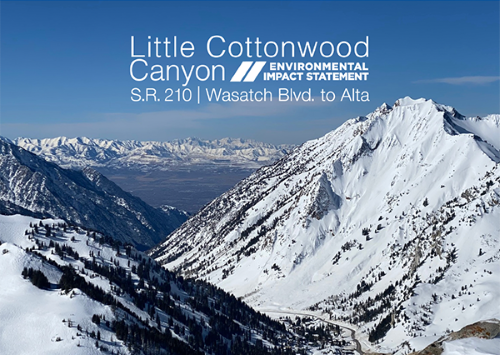
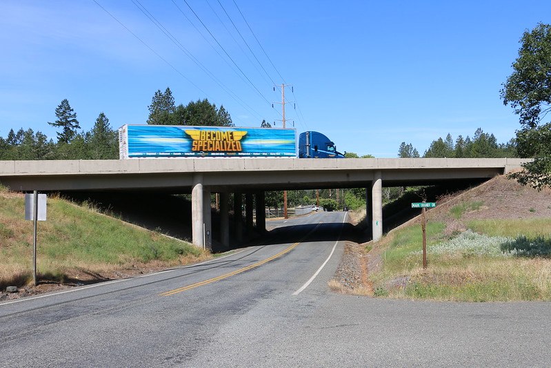
The Utah Department of Transportation identified two “preferred alternatives” to improve transportation in Little Cottonwood Canyon in a draft Environmental Impact Statement or EIS issued on June 24 – alternatives that deliver mobility and reliability benefits while minimizing impact on water quality, air quality, plus visual/noise affects, among others.
[Above photo by Utah DOT]
Along with a 45-day public comment period on the EIS – which ends on August 9 – the Utah DOT said in a statement that it plans to host an in-person public open house and a hearing on July 13 to review both alternatives: events that will be livestreamed and recorded as well.
Based on its technical analysis – a process started three years ago – Utah DOT identified the Enhanced Bus Service in Peak-Period Shoulder Lane as the alternative that “best improves” mobility for the project, while the Gondola Alternative B is alternative that best improves transportation reliability.
The Enhanced Bus Service in Peak-Period Shoulder Lane Alternative offers bus-only shoulder lanes on State Route 210 from North Little Cottonwood Road to the Bypass Road for peak travel times. With this alternative, bus service is removed from congestion and able to pass slower moving traffic in the general-purpose lane, providing direct service to each destination. Of the alternatives examined, this bus option offers the fastest travel time and the second lowest cost. Meanwhile, pedestrians and bicyclists could use the improved shoulders when the buses are not operating, the agency said.
The Gondola B alternative would construct a base station approximately one mile from the mouth of Little Cottonwood Canyon and offer direct service to each destination. Each gondola could hold up to 35 people and travelers could expect a cabin to arrive every two minutes. The Gondola base station includes 1,500 parking spaces, reducing the need for passengers to use bus service from the mobility hubs. It also can operate “independently” of S.R. 210, avoiding delays related to snow removal, avalanche mitigation, crashes, slide offs, and traffic.
The Utah DOT added that while the Gondola B alternative creates the highest “visual impacts,” it minimizes effects on wildlife movement, climbing boulders, and the area’s watershed compared to the other alternatives. It is also the more expensive of the two options – clocking in at $592 million, with an annual winter operation cost of roughly $7.6 million. In addition to the preliminary preferred alternatives, the EIS highlights other elements within the project to support each alternative. These include snow sheds (concrete structures built over the highway to keep it clear of snow in case of avalanches); mobility hubs (larger-capacity park-and-ride lots with transit service); widening and other improvements to Wasatch Boulevard; tolling or single occupancy restrictions; addressing trailhead parking and eliminating winter roadside parking above Snowbird Entry 1.
The National Cooperative Highway Research Program (NCHRP) released a report in February 2021 highlighting several state agency efforts to incorporate Green Infrastructure (GI) solutions into transportation drainage and landscaping design.
The American Association of State Highway and Transportation Officials helped research and publish that report – entitled Landscape Design Practices for Roadside Water Management: Domestic Scan 16-02– as part of the joint AASHTO and Federal Highway Administration’s NCHRP “Domestic Scan Program.” That program helps speed up the transfer of information and technology among transportation agencies.
This article is the second of a two-part series – focusing on GI recommendations for state transportation agencies.
How and where can state departments of transportation incorporate Green Infrastructure or “GI” practices into their ongoing infrastructure programs? A four-day workshop organized by the team that crafted the Landscape Design Practices for Roadside Water Management: Domestic Scan 16-02 report came up with eight recommendations that can help build a successful GI program with long-term results, across varied climates, geographies, and topographies.
[Above photo by Colorado DOT]
The first is to define what GI is, as the workshop participants discerned at the outset that there is no nationally recognized standard GI definition – and an agreed-upon definition is needed to support grant funding consistency, federal eligibility, categorization of GI projects, design approaches, and recognition in the transportation realm.
As a result, the report team recommended that AASHTO, in conjunction with FHWA, develop a national GI definition as it relates to transportation for consistent adoption throughout the country – one also be incorporated into “A Policy on the Geometric Design of Highways,” which is known colloquially as the “Green Book.”
Steve Sisson – a design resource engineer with the Delaware Department of Transportation and member of the AASHTO Technical Committee on Hydrology and Hydraulics – believes there are several other areas where more GI information could be included in AASHTO documents.
He pointed to two current AASHTO publications – Highway Drainage Guidelines (HDG) and Drainage Manual (ADM) – currently undergoing updates to incorporate GI and new stormwater management (SWM) systems earlier into the infrastructure design process. Those particular areas include advancing setting-based site assessment, runoff reduction opportunities, and public private partnerships.
“The latter also will include support for more watershed-based approaches that minimize long term maintenance costs while increasing return on investment for public and private dollars,” Sisson explained.
“[Those] updates will draw on additional studies like NCHRP Research Report 840, ‘A Watershed Approach to Mitigating Stormwater Impacts,’ and NCHRP 25-60. ‘Watershed Approach to Mitigating Hydrologic Impacts of Transportation Projects,’” he said.
Sisson added that the GI section would also include an expanded generic Best Management Practices or BMP library, applicable over a wide range of regulatory jurisdictions, incorporating maintenance and construction recommendations.
The other recommendations made by the report team include:
Maintenance:Considered the most important project-related category identified for the success of GI, the teams believes in integrating maintenance plans incorporating GI elements into all transportation projects. However, training is needed to ensure proper workflow and actions for the GI solutions. Personnel with the right expertise and equipment are essential, along with policies, procedures, guidance, and manuals with standard operating procedures and maintenance plans to ensure long-term consistency in practice.
Watershed Approach versus Project Site Approach:GI solutions are often not available as an option when constrained by right of way or ROW on project sites. State DOTs typically obtain ROW in linear segments in alignment with the roadway, which can limit the opportunity for some GI practices, such as bio-retention areas, because there is not enough space within a linear ROW for effective treatments to be built. By taking a watershed approach and partnering with other agencies, the area for building GI is greatly increased. It is important for state DOTs and regulating agencies to develop common goals and outcomes for a watershed approach as well as educate practitioners on the benefits.
Information Sharing:The team identified a lack of generally available education, training, and research for interested agencies on the use of GI. While there is a considerable amount of information about SWM and GI, there is no central repository or clearinghouse for that information and research. The team recommends development more GI based conferences, peer exchanges and a data repository located on a free website to encourage the implementation of more GI solutions.
Public Outreach: Public and political support is important for acceptance GI infrastructure solutions as well as to obtaining funding for those solutions. Educating the public on the importance of GI to clean water and clean air shows both them and decision makers the environmental, social, and economic benefits. The team recommended that state DOT public information officers or communications experts develop a “GI factsheet,” relevant signage, and other materials to provide the public with a good understanding of the locations and importance of GI.
Asset Management: State DOTs track highway assets such as bridges, barrier rail, and pavement miles, but currently stormwater and GI are not necessarily included in geospatial tracking systems. Including GI in the general agency-wide asset management system allows a state DOT to report to regulatory agencies the types and quantities of GI components that are in place for stormwater controls. It also allows an agency to plan and budget for necessary maintenance staff, inspections, materials, supplies, and scheduling.
Design: GI and components often do not have a standardized design within DOTs. Design guidance would vary somewhat according to regional and local geography and climatic conditions, each state could develop standard criteria and design guidelines in order to prevent having to develop designs strictly on a project-by-project basis.
Construction Inspection: Vegetation establishment is a consistent challenge on transportation projects and issues that include process quality control, contractor compliance with specifications, and contractor and state DOT field personnel understanding of the overall re-vegetation process and specifications. The report team would like to see development of a process for ensuring correct implementation of permanent and temporary stormwater and GI features. The process would also include sequencing/time frames (e.g., contract hold points) for critical work and vegetation establishment. The team also recommended that standardized, recognized infiltration tests, such as ASTM standards, would be necessary for a successful program.
Overall, the report team believes that by using a holistic approach incorporating recommendations from those eight concentration areas, transportation agencies can provide long-term successful GI solutions to their roadway project.
The National Cooperative Highway Research Program (NCHRP) released a report in February 2021 highlighting several state agency efforts to incorporate Green Infrastructure (GI) solutions into transportation drainage and landscaping design.
The American Association of State Highway and Transportation Officials helped research and publish that report – entitled Landscape Design Practices for Roadside Water Management: Domestic Scan 16-02– as part of the joint AASHTO and Federal Highway Administration’s NCHRP “Domestic Scan Program.” That program helps speed up the transfer of information and technology among transportation agencies.
This article is the first in a two-part series – focusing on the state of the practice in GI in several agencies, as well as policies in place and challenges found in the industry. The second article will focus on recommendations for the future of GI implementation state transportation agencies.
According to the FHWA, “green infrastructure” is defined as “strategically planned and managed networks of natural lands, working landscapes and other open spaces that conserve ecosystem values and functions and provide associated benefits to human populations.” It also applies to various water management approaches where transportation infrastructure is concerned, including technologies that “infiltrate, evapotranspire, capture, and reuse stormwater to maintain or restore natural hydrologies.”
[Above photo by the Virginia DOT]
The NCHRP’s new report — Landscape Design Practices for Roadside Water Management: Domestic Scan 16-02 – developed a more specific definition for GI. That definition included “roadside stormwater management, Low Impact Development or LID, hydro-modification, and watershed actions that conserve water, buffer climate change impacts, improve water quality, water supply, public heath, and restores and protects rivers, creeks and streams as a component of transportation development projects and operations.”
The team compiling the report found, however, that the practice of incorporating GI is inconsistent among state departments of transportation – employed only when required. Overall findings suggest GI is not yet a part of the state DOT stormwater management toolbox and is not routinely employed as a standard stormwater management method.
That team included:
Jennifer Taira, senior landscape architect for the California Department of Transportation and chair of AASHTO’s NCHRP committee.
Ken Graeve, erosion and stormwater management unit supervisor with the Minnesota Department of Transportation
Charles Hebson, manager of the surface water resources division for the Maine Department of Transportation
Garrett Jackson, a hydrologist with the Washington State Department of Transportation
Laura Riggs, LRSP and SRTPP program manager for the Louisiana Department of Transportation
Brian Smith, ecologist and biologist for the FHWA
Lucy Joyce, former landscape architect supervisor with the Nevada Department of Transportation
That team further investigated how leading transportation agencies are applying principles and practices of GI for roadside water management and then planned to develop recommendations to help agencies look to the future of a higher level of implementation.
A central finding of this report is that, historically, managing the “peak flow” of water off roads to nearby waterways has been the traditional focus of transportation infrastructure design via techniques such as “gray infrastructure,” which includes culverts and pipes, to move the water offsite quickly. However, the report found that approach is sometimes neither the most efficient nor cost-effective in terms of managing that water flow. Newer GI techniques – such as water harvesting, landform grading, rain gardens, micro-catchment basins in arid climates, and large-watershed – are proving to be more efficient “green solutions.”
Photo via WSDOT
On top of that, many of the GI practices in use today resulted from various regulatory requirements for clean water/clean air imposed by the Environmental Protection Agency as well as state departments of environmental protection/quality. Yet the report discovered that many of those regulatory efforts – typically at the state level – often included barriers that hindered a state DOT’s ability to fully or successfully implement the switch to more efficient and low cost GI practices.
For example, the “gray” approaches to managing stormwater runoff from roads and highway can actually contribute to the problems of flooding and stormwater pollution in some cases.
To discern what GI practices work best, the report team sent out a survey to seven state DOTs (Arizona, Maryland, Michigan, Nevada, Oregon, Pennsylvania, and Washington) and five cities, counties, or regional agencies (Philadelphia, Pennsylvania; New York City, New York; Long Creek Watershed Management District, Maine; Southeast Michigan Council of Governments [SEMCOG], Michigan; and King County, Washington).
Photo via Maryland DOT
In addition to the survey responses, the team met directly with several of them during a series of three-day workshops.
The survey and workshop discussions resulted in a series of key GI implementation focal points:
“Intensity of regulations really affects what gets implemented.”
“Technology matters, especially geospatial data management.”
“Training/education is important in implementing effective maintenance”
“Watershed approach is key.”
“Planning level of DOTs is important to coordinate stormwater needs and optimize opportunities.”
“Maintenance is important; we could have an entire scan on maintenance of these solutions”
“Standards, codes, policy, ordinances as important tools for driving/enabling green stormwater infrastructure”
While the survey answers and workshop discussions highlight “significant movement” toward more use of GI solutions in landscaping and storm water management, the funding, support, construction, and maintenance practice for GI remained inconsistent.
As a result, the report team outlined eight recommendations to promote GI practices among state DOTs in the future — recommendations detailed in part two of this series next week.
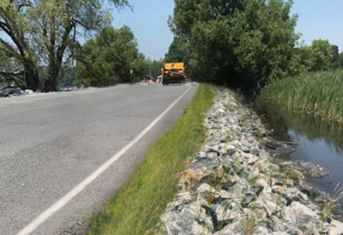
The New York State Department of Transportation is heading up a $5.4 million project to “harden” a local roadway against damage from flooding and other weather events through the state’s Resiliency and Economic Development Initiative or REDI.
[Above photo by NYSDOT.]
The project focuses on a 1,800 linear foot section of County Road 57 – a critical connection that provides the only land access to Point Peninsula, an island community within the Town of Lyme near Lake Ontario.
Resiliency measures for this project include raising the vulnerable section of roadway three feet to mitigate potential flooding and halt further road deterioration. Additionally, the agency is installing “rip rap” – a term for human-placed rock formations – to provide further protection against the impact of wind, waves, and ice formation.
“Vital infrastructure along Lake Ontario has been adversely affected from severe flooding,” explained Governor Andrew Cuomo (D) in a statement. “Through REDI, and through the State’s partnership with local governments, these critical assets are being reimagined and rebuilt to mitigate future damage and disruption, ensuring public safety and safeguarding local economies.”
“By working together with our local partners and making smart, targeted investments like this one, New York is moving forward in the battle against climate change,” added Marie Therese Dominguez, NYSDOT commissioner. “These REDI projects will harden infrastructure, mitigate flooding and assist local communities in combating the rising waters of Lake Ontario for years to come.”
Gov. Cuomo created the REDI program in the spring of 2019 in response to an “extended pattern of flooding” along the shores of Lake Ontario and the St. Lawrence River. Five REDI Regional Planning Committees comprised of representatives from eight counties – Niagara, Orleans, Monroe, Wayne, Cayuga, Oswego, Jefferson, and St. Lawrence – work to identify “at-risk” infrastructure and public safety concerns.
The REDI Commission has to date allocated $20 million for homeowner assistance, $30 million to improve the resiliency of businesses, and $15 million toward a regional dredging effort that will benefit each of the eight counties in the REDI regions. It allocated the remaining $235 million towards local and regional projects that “advance and exemplify” the REDI mission.
Over the last two years, some 133 local and regional projects are now underway, including 107 projects in the design phase, 13 projects in the construction phase, and 13 projects completed.
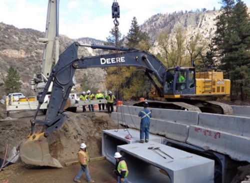
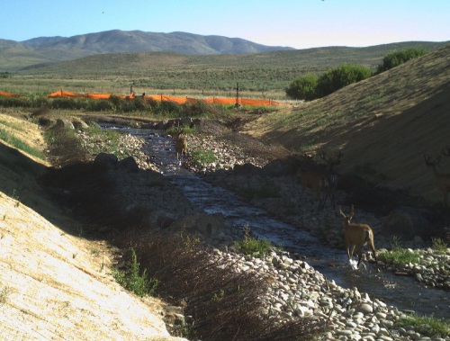
The construction of the new Rock Creek Bridge to replace a culvert on US-20 recently won an engineering excellence award from the American Civil Engineers Council of Idaho – an award shared by the Idaho Transportation Department (ITD) and Jacobs Engineering.
[Photo by the Idaho Transportation Department.]
The new bridge now allows wildlife to pass under the highway, reducing the risk of possible collisions involving wildlife and vehicles on the roadway. The ITD added in a statement that this particular section of US-20 witnessed 64 vehicle-wildlife collisions over the last five years, which totals a “societal cost” of approximately $2 million when adding together the cost of vehicle repair or replacement, medical bills, and increased insurance rates – not to mention the cost to wildlife.
The project also allowed the ITD to restore the streams forded by the new bridge to a more natural condition, which in turn should positively benefit the surrounding ecosystem by encouraging safer fish passage under the highway.
Building a bridge also reduced the impact on the local environment versus replacing the existing multi-plate culvert with a similar culvert design, ITD added.
This was one of ITD’s first projects incorporating ‘fabric encapsulated soil lifts’ into a design – a way to ensure streambank stability as water levels rise and fall while still promoting vegetative growth. The project has already improved the environment while enhancing the safety and the natural beauty of the project area, ITD added. Just a few months after construction, the agency spotted fish swimming upstream to spawn, while noting several deer – and a moose – traveled along the channels under the bridges.
Recent hydrological studies indicate to the California Department of Transportation that it can rebuild a washed-out section of the famed Pacific Coast Highway with a massive new drainage system that would protect the roadway well past the 22nd Century.
[Photo courtesy of the California Department of Transportation.]
Three days of heavy rains spawned a river of mud, boulders, and fire debris on January 28 that overwhelmed a 150-foot section of the iconic Highway 1, sending it into the ocean. A five-mile section of the roadway remains closed at Rat Creek on Monterey County’s Big Sur Coast while contractors work toward an early summer re-opening.
“We’re returning the road to how it was before, but with modern engineering,” said Caltrans Public Information Officer Kevin Drabinski.
The washout left a V-shaped cavity where the old fill had cradled a 66-inch culvert for Rat Creek. Contractors will re-fill, compact the material, and bore the fill to accommodate a 10.5-foot culvert before rebuilding the roadway atop the fill.
Drabinski said the new drainage system would also feature a secondary culvert and some smaller culverts closer to highway grade, providing redundancy should another major incident occur.
Photo courtesy of the California DOT
“Our hydrological studies looked at models of another large fire followed by intensive rain,” he noted. “We’re confident this new design will stand for centuries to come.”
Drabinski added that the old culvert was installed decades ago and simply couldn’t handle the swollen creek that carried boulders, fire debris, mud, and a lot of water, all fueled by 17 inches of rain in three days. A massive tree trunk jammed the culvert, turning the creek into a lake and the highway into a dam. Eventually, the water and debris overtopped and washed out the road.
Contractors are hauling away tens of thousands of cubic yards of fill material while also properly disposing of the debris left behind by the landslide, Drabinski pointed out.
“There are designated sites for the debris haul,” he said. “We have very specific rules about how we dispose of that. You can’t just haul it away. You can’t throw a mudball into the Pacific Ocean.”
Caltrans believes it can finish the work by early summer, depending on rain. Crews are working every day, “and we’re making hay while the sun shines for now,” Drabinski emphasized.
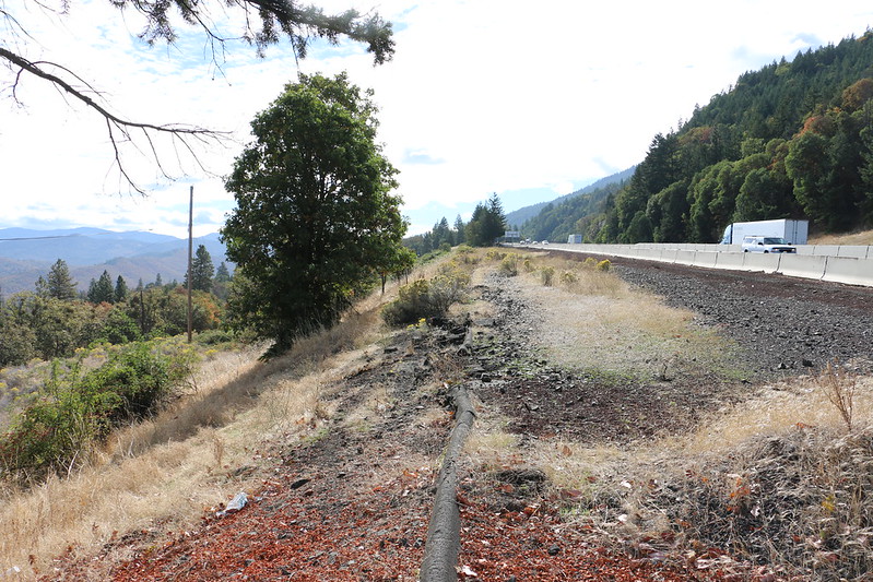
The Oregon Department of Transportation contractor has officially started work on a series of “bridge bundles” associated with the Southern Oregon Seismic Resiliency project.
[Photo courtesy of the Oregon Department of Transportation.]
That three-year-long, $45 million project – funded by the 2017 Keep Oregon Moving legislative package – seeks to rebuild or reinforce 17 bridges and seven slopes that could be affected by the Cascadia Subduction Earthquake Zone.
The agency noted in a statement that the first “bridge bundle” being addressed within this project is an effort to strengthen Interstate 5 Exit 80 bridges near Glendale. Other bridges in this first $12.7 million “bundle” include the I-5 Exit 58 north Grants Pass interchange bridges and the nearby I-5 Hillcrest Road Bridge near milepost 57.5.
In a November 2020 blog post, the Oregon DOT noted that experts say there is a one-in-three chance a Cascadia Subduction Zone earthquake could occur within the next 50 years. The concern is that a major earthquake would isolate much of that region due to bridge damage or outright destruction, with landslides triggered by an earthquake blocking key roadways.
Photo courtesy of the Oregon Department of Transportation
Thus the idea behind the Southern Oregon Seismic Resiliency project is to “armor” key southern Oregon bridges and hillside slopes before a big earthquake strikes.
“The idea is to prepare now so the area can get back on its feet as quickly as possible, to get the region reconnected to the outside world,” explained Chris Hunter, Oregon DOT’s project manager. “How can we act strategically now to improve key bridges and known problem slopes to keep critical, life-saving goods flowing into and out of the region?“
He said Oregon DOT crews have prioritized or evaluated the most vulnerable bridges and slopes to keep the Rogue Valley connected along the I-5 corridor to Eugene and the Willamette Valley, as well as from the Rogue Valley east to the U.S. 97 corridor over Oregon 140. The plan is to quickly clear some kind of roadway connection – in the days and weeks after a subduction zone quake – even if it is a single lane or two. By keeping that connection, critical supplies can get into and out of the area, Hunter noted.
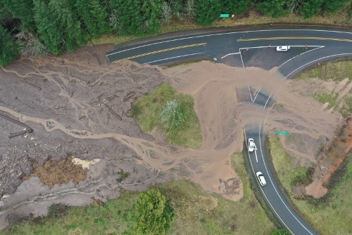
The Oregon Department of Transportation noted in a recent blog post that landslides could increase in 2021 due to topographical damage caused by a series of devastating wildfires in 2020.
[Photo courtesy of the Oregon Department of Transportation.]
In order to track how landslide activity is influenced by wildfires, earthquakes, and climate change, the agency is in the midst of several projects that record and analyze landslide activity via ground- and aerial drone-based sensors.
[The video below, captured by an Oregon DOT drone, illustrates the type of transportation system damage that can be caused by landslides.]
To that end, Curran Mohney – senior engineering geologist with the Oregon DOT’s statewide project delivery group – is involved in an effort to monitor landslides affecting the state’s coastal highways. That project – in year four of its seven-year life – is being conducted in collaboration with students and professors from Portland State and Oregon State universities.
“Primarily what I want to know is how much time we have left for our highways in certain areas,” Mohney explained. “What’s the life span of our highways on the coast and in our stressed areas? How fast are landslides accelerating, especially with climate change drivers? How long until we lose that battle?”
He added that this project is “increasing knowledge” that will benefit the state in many ways – especially in terms of protecting its surface transportation network.
[The video below highlights the equipment and techniques deployed by the Oregon DOT and its contractors to repair roads damaged by landslides.]
For example, Mohney said every landslide has elements that indicate its approximate age: its shape and radiocarbon dating of buried animal bones and plant matter. Depending on what the research team discovers from that material helps determine whether a landslide occurred because of seismic events or just from heavy rains.
“Learning about the age and the causes of slides can help us make better decisions about our seismic lifelines or things we need to do to adapt to climate change impacts,” Mohney said.
“It’s telling us things about how and why landslides happen in certain places,” he added. “Just imagining what our issues are going to be with climate change and Cascadia [the Cascadia Subduction Zone Earthquake] – it seems insurmountable. So if we can figure out anything about where, why, how, then we can be prepared. Maybe we can go out ahead of time and make smart decisions.”
The California Transportation Commission released recommendations on November 16 for a $2 billion three-year program to fund new projects to reduce traffic, improve goods movement, increase transit service, and invest in bicycle and pedestrian improvements across the state – projects that also would create more than 100,000 jobs statewide.
[Photo courtesy of the California Department of Transportation.]
Overall, approximately 60 percent of the $2 billion funding recommendation would go to areas in Southern California and 40 percent to areas in Northern California, which reflects the funding distribution historically used for transportation projects in California. This “geographic balance” ensures communities throughout the state share equitably in the transportation benefits and the jobs created, which will help the state’s economic recovery, the commission said.
“The projects we’re recommending will boost the state’s economy and help transform our transportation system to become more efficient,” said Mitch Weiss, the commission’s executive director, in a statement.
Mitch Weiss, Executive Director, California Transportation Commission. Photo courtesy CTC.
“We’re proposing large investments in transit and bicycling projects that will take cars off our roads, reducing greenhouse gas emissions in support of our climate goals,” he added. “We’re proposing investments in new lanes at choke points where trucks get stuck trying to move the goods our economy depends on, as well as carpool, express, and bus rapid transit lanes so people can get home from work faster to spend more time with their families.”
The proposed transit projects within that $2 billion program aim to make public transportation more accessible and reliable by adding new transit stations and modernizing and expanding services, the commission noted – pointing to the Bay Area Rapid Transit Train Control Modernization project as an example.
Transit projects such as that one are “critical for getting more people out of their cars and moving California toward its goal of reducing greenhouse gas emissions to at least 40 percent below 1990 levels by 2030,” the commission stressed.
The freight sector, which is responsible for an estimated one-third of the state’s economy and jobs, also would benefit from projects to improve highway interchanges; add lanes at choke points for trucks; and upgrade truck inspection and border crossing facilities. For instance, the I-80 Cordelia Vehicle Enforcement Facility project would replace an outdated truck inspection facility along I-80 in Solano County with a new facility using “weigh-in-motion” scale technology, increasing freight volume by 8 million trucks over two decades. More broadly, the commission noted that it fit a variety of “multimodal” corridor projects within its $2 billion recommendation package – combining highway improvements, such as adding new merging lanes to smooth the flow of traffic and improve safety, with increased transit service and bicycle and pedestrian improvements on nearby streets to provide a safe alternative to driving.
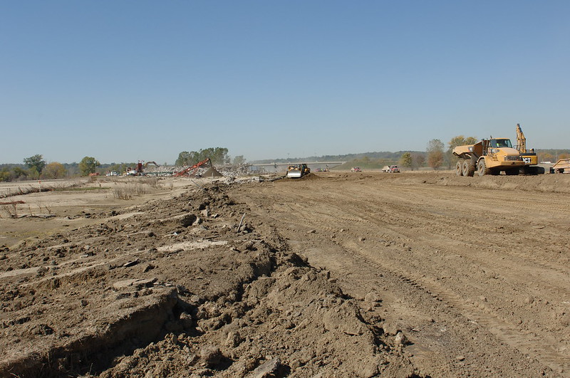
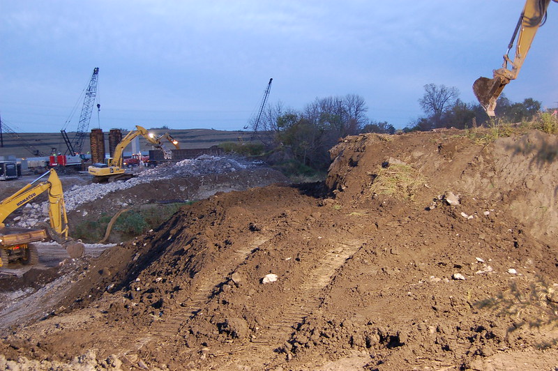
To determine the effectiveness of its erosion- and sediment-control techniques, the Iowa Department of Transportation recently teamed up with Iowa State University over two construction seasons to establish which ones worked the best and which ones needed improvement.
[Photo courtesy of Iowa Department of Transportation.]
According to an Iowa DOT blog post, Melissa Serio with the agency’s construction and materials group teamed up with Mike Perez, an Iowa State researcher, to examine alternative erosion and sediment control techniques and adaptations used successfully by other transportation agencies to see how well the Iowa DOT’s standard practices.
Some of Iowa DOT’s frequently used erosion and sediment control techniques include: fabric silt fences to slow water flow and collect sediment; porous mesh tubes (called wattles) filled with straw or other material to control storm water flow; sediment basins or small retention ponds to hold water until solid materials can settle; and rock check dams.
“While we were convinced these elements help control erosion and sediment, it wasn’t clear whether these were the most effective or whether there were other approaches that could be undertaken to achieve better or less expensive results,” Serio explained. “It was important to understand the feasibility of possible changes to practice and identify the right improvements that could be put in place at the right price.”
Photo courtesy of Iowa DOT
While some of Iowa’s existing techniques already performed well, several potential improvements became apparent over the course of the two-year study. For example, simple adjustments to silt fences included reducing the space between posts, adding wire support to the fence’s fabric backing, and cutting a notch, or weir, at the top of the fence so that overtopping of water could be directed to the most desired location.
Even as the research pointed to potential new best practices, the Iowa DOT said this study “also challenged our expectations.” For example, sediment basins appeared not to be as effective a sediment control measure as had been previously thought. In fact, some data collected suggested that water leaving the basins might have more sediment than it had when entering.
“Further research in a controlled environment will provide more insight, but these initial findings are extremely valuable as we seek to maximize the effectiveness of our erosion and sediment control measures,” the agency noted. “We plan to include the most effective and cost-efficient erosion and sediment control treatments identified in this research project as part of standard road plans in the near future – mostly likely beginning the spring of 2021,” the Iowa DOT said.