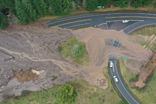
The Oregon Department of Transportation noted in a recent blog post that landslides could increase in 2021 due to topographical damage caused by a series of devastating wildfires in 2020.
[Photo courtesy of the Oregon Department of Transportation.]
In order to track how landslide activity is influenced by wildfires, earthquakes, and climate change, the agency is in the midst of several projects that record and analyze landslide activity via ground- and aerial drone-based sensors.
[The video below, captured by an Oregon DOT drone, illustrates the type of transportation system damage that can be caused by landslides.]
To that end, Curran Mohney – senior engineering geologist with the Oregon DOT’s statewide project delivery group – is involved in an effort to monitor landslides affecting the state’s coastal highways. That project – in year four of its seven-year life – is being conducted in collaboration with students and professors from Portland State and Oregon State universities.
“Primarily what I want to know is how much time we have left for our highways in certain areas,” Mohney explained. “What’s the life span of our highways on the coast and in our stressed areas? How fast are landslides accelerating, especially with climate change drivers? How long until we lose that battle?”
He added that this project is “increasing knowledge” that will benefit the state in many ways – especially in terms of protecting its surface transportation network.
[The video below highlights the equipment and techniques deployed by the Oregon DOT and its contractors to repair roads damaged by landslides.]
For example, Mohney said every landslide has elements that indicate its approximate age: its shape and radiocarbon dating of buried animal bones and plant matter. Depending on what the research team discovers from that material helps determine whether a landslide occurred because of seismic events or just from heavy rains.
“Learning about the age and the causes of slides can help us make better decisions about our seismic lifelines or things we need to do to adapt to climate change impacts,” Mohney said.
“It’s telling us things about how and why landslides happen in certain places,” he added. “Just imagining what our issues are going to be with climate change and Cascadia [the Cascadia Subduction Zone Earthquake] – it seems insurmountable. So if we can figure out anything about where, why, how, then we can be prepared. Maybe we can go out ahead of time and make smart decisions.”